Here’s the next installment, recounting the events of the Wednesday & Thursday of our week in the park:
Day Five (Wednesday, July 1st)
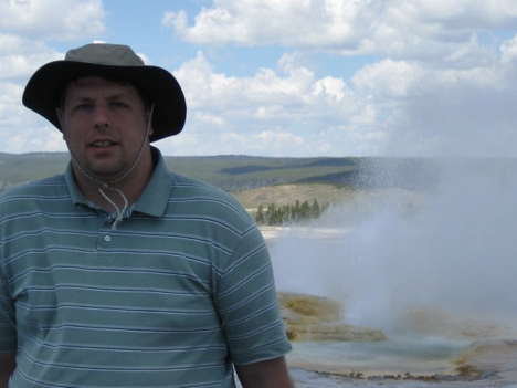
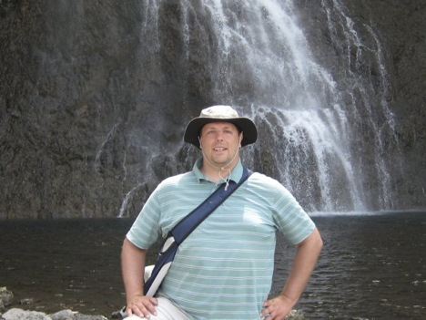
One worthwhile tidbit that we actually did pick up from the film presentations at the Canyon Village visitor center on Tuesday was that scenic lake cruises could be had on Yellowstone Lake from the Bridge Bay area. We thought that this would be fun, so, upon once again rising bright and early on this day (I, for one, was sleeping much better than I often do in the tent for most of this trip; I found a good way to arrange things so that my head was well-supported, and I discovered that my sleeping bag is still really warm even if unzipped and used blanket-style, which was far more comfortable), we headed up to the Bridge Bay Marina and went into the little office there. We learned that the day’s first scenic boat tour would depart in perhaps forty-five minutes or so (I don’t remember exactly), so we bought tickets. There was a little store at the marina, and Jen had suggested, in light of my sunburned forehead from Monday and continuing worries about getting still more sunburned, that I needed a hat—so we went into the store to shop for one while we waited for the boat tour. I jokingly expressed interest in a coonskin cap, but ultimately ended up buying something less silly.
Hat acquired, we then killed most of the remaining time until the boat was scheduled to depart by wandering down a trail that led away from the marina along the shore. Eventually, we headed back to the marina and waited in line by the dock to be let onto the boat, which turned out to be an entirely enclosed craft somewhat unlike what we’d imagined. Still, the lake scenery was cool, and the interpretive guide conducting the tour had lots of really interesting stories to tell about the history of the lake area of the park.
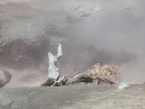
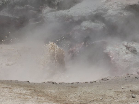
The main roads in the central area of the park form a big loop, and Grant Village and our campground lay just off this loop via another main road heading south from the middlish portion of the bottom of the loop. The Bridge Bay area, Hayden Valley, and Canyon Village all lie along the eastern part of the loop, and the various geothermal features are mainly along the western part (except for the ones that aren’t). It’s difficult to remember quite what our thinking was about where we were going and what we were doing on this day, but one way or another, we ended up down, around, and up the western side of the loop, after having started the day by going up the eastern side to Bridge Bay Marina for the boat cruise. Part of the reason, I guess, was that we’d decided to check out Fountain Paint Pot—another mudpot area, which was eerily cool like all such areas in the park are but which, perhaps, didn’t photograph exceptionally well.
I believe that, since we were right by it, we ended up stopping at the Whiskey Flats picnic area again for lunch either before or after Fountain Paint Pot. Next, we drove further up the west side of the loop to the Madison area, where we went to a little combination bookstore and ranger station. I really don’t recall what our purpose was in going there, other than that we had general notions about getting trail maps and doing some hiking somewhere in the area (but why there in particular, I can’t say). This, I think, was sort of the moment during our time in Yellowstone when, having seen the “major” sights that we’d (or at least I’d) known about in advance, and having run into obstacles in the way of some of the other activities we’d hoped to do during our trip, there was somewhat of a sense of uncertainty about what else we wanted to do while we were there—not that there was any shortage of things to see, by any means, but just that we’d exhausted the list of things we’d explicitly wanted to do rather quicker than expected due to our inability to do some of them. In any case, though, while we were in this little bookstore, I happened across a book entitled Yellowstone Trails: A Hiking Guide. This, at the risk of sounding like an advertisement, is a comprehensive guide to all the hiking trails in the entire park (there are more than 100, it says), and it seemed like a great thing for a couple of people who were not sure what they wanted to do for the rest of their time at Yellowstone to buy—so buy it we did. This nifty little book (which came with a big poster-sized color map of the park that will be going up on a wall somewhere in our house at some point) kind of opened my eyes (whether I can speak for Jen as well and say “our eyes,” I’m not sure) to all the hiking that one can do in the park beyond just the boardwalks and short trails around the major attractions, as well as to the sheer number of beautiful little creeks and waterfalls, topographic features, and scenic vistas that can be reached and explored by setting off on the hiking trails.
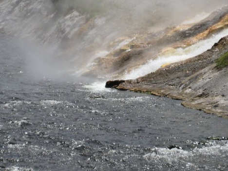
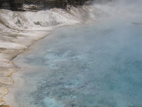
A quick perusal of the sections of the book that detailed trails in the general area where we were suggested a variety of possibilities to us, but first, there was another one of those one-way scenic drives looping off the main road just south of Madison Junction (where the bookstore was) that we decided to check out. This one was called Firehole Canyon Drive—as distinct from the Firehole Lake Drive that we’d explored in search of the reported swimming area on Monday afternoon. The Firehole River winds through this area of the park and is the basis for these names; it’s a picturesque little stream that the water from a variety of geysers and hot springs flows into as it winds among them. Its clear blue water always looked very cool and refreshing, and by now, I’d seen enough people wading into it here and there (from fisherpersons in hip boots to families with kids and assorted other people taking off socks and shoes and enjoying the cool water) that I’d decided that if I couldn’t go swimming while we were here, I was at least going to get my feet wet in this or one of the myriad other little creeks at some point. In any case, as we puttered along Firehole Canyon Drive, I was enjoying the scenery and keeping an eye out for places to go wading, when—lo and behold—we encountered a sign marking a swimming area! Okay—so maybe the woman at the laundry place had simply told me “Firehole Lake Drive” when she meant “Firehole Canyon Drive”? For a heartbeat, I got all excited—but Jen, who wasn’t driving, had time to read the rest of the sign, which announced that the swimming area was closed due to high water creating dangerous conditions. Well, that was that—I definitely wasn’t going to be able to go swimming at Yellowstone.
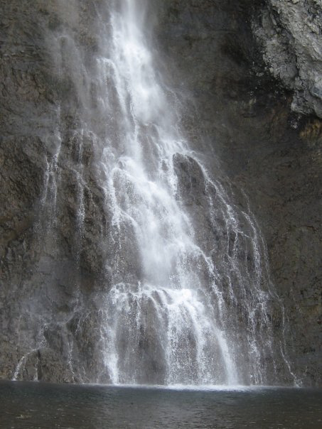
Ironically, however, our next activity demonstrated vividly to me that I actually could have gotten myself in the water, if only I’d been a little more prepared. From among the various options for hiking in the area, we selected the shortest of several trails leading to a waterfall called Fairy Falls. It was 2.5 miles from the starting point to the falls, so our round-trip hike would be about 5 miles long—a pretty decent distance to walk, at least for a low-endurance wimp like me. The trail started from a parking area along the road, a short ways south of the Midway Geyser Basin parking area (a geyser & hot spring area that we hadn’t visited yet, but would visit on Thursday). The first mile of it was actually an old dirt road that led to the real trail, which was a narrow track through rocky terrain and young pines that have grown up since the big fire of 1988. This particular hike proved to be a major high point of the trip for me, even though (okay, actually partly because) it was also the occasion of the official Funnest Thing I Didn’t Do on the trip. For one thing, I really felt like I hit my stride, hiking-wise, at this point; instead of enduring the walking because that was how one got to the places one needed to go to see the sights, the hiking itself became fun, and any doubts about being able to find things to do for the rest of the trip vanished as, more fully acclimated now to the elevation, I began to feel like I could hike through all this gorgeous terrain for hours, day after day. (Admittedly, the going was much easier on this trail than it had been on the steep canyon trails of the previous day—but that wasn’t all there was to this.) As we walked along the broad, straight dirt road part of the hike, a hot spring off in the middle distance to our right was giving off blue- and orange-tinted steam (I tried to photograph this, but it didn’t really work). When we got to the “real” trail, the hike became even more fun. Eventually, we arrived at the foot of the extremely high falls. It was a delightful little spot, rocky, shady, and with a little pool at the bottom of the falls—almost like something out of a movie set in a jungle or on a tropical island, except, of course, not actually tropical.
There were several other people lingering there who had obviously also hiked one of the trails to the spot, and just as I was thinking that this would have been a fantastic place to go wading, if only I’d brought my sandals, a youngish, bikini-clad woman who did have sandals on, and whom I hadn’t even seen until that moment, went splashing out into the little pool. I could tell from her body language by the time she was in up to her knees that the water was pretty cold, but that didn’t seem to faze her much; she clearly meant to cross over to the actual foot of the falls and feel the spray coming down from above. The bottom of the pool was rocky and looked far too treacherous for bare feet, so there was definitely no wading in for sandal-less me—but I watched enviously as this girl crossed to a point right next to the falls (by which point she was in up to her waist) and raised her arms up into the spray, and I did my best to enjoy the experience vicariously through her. As I mentioned, it was the Funnest Thing I Didn’t Do on the trip.
As we started back along the trail, I made a mental note to bring my sandals along in the bag that we were using to carry water & whatnot in on all future hikes, and I daydreamed aloud about how much fun it would be to hike to a spot like this one sometime and have a picnic lunch there (if carrying the food along on the hike were to prove feasible), and go swimming, and generally experience summer-vacation-heaven.
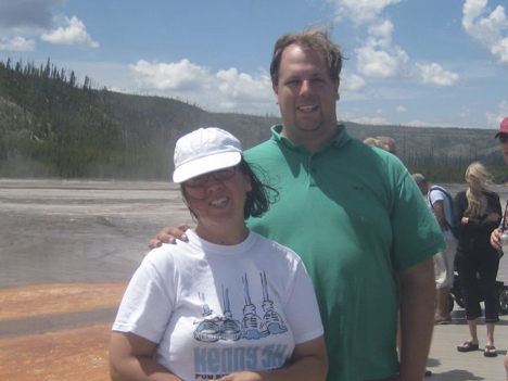
We were starving by the time we got back to the car. Since this whole trip was in honor of our anniversary and had originally been planned for the actual week of said anniversary (i.e. the week before this one), we had figured that although we would mostly be cooking our meals over a fire pit, we’d find ourselves a nice restaurant and have a nice expensive anniversary dinner one night during the trip, as we’ve done during at least one or two past anniversary trips. Today was exactly one week past our actual anniversary, and would, I reasoned, have been our anniversary if the trip had happened the previous week—so it was officially our “honorary” anniversary, and therefore the day for our planned dinner. The closest of the park’s various little “villages” where stores and restaurants and such are found was the Old Faithful area, and although we really had no idea what dining options we would find there and how they might compare to what we might find elsewhere in the park, we decided to at least stop there and inquire in the visitor center about dining options. If there were any right there that appealed to us, we’d go with that—and if not, we’d head back to Grant and try one of the eateries in that “village.” As it turned out, there were two nice restaurants by Old Faithful. The first one proved to be insanely spendy and rather short on appealing menu options (their menu was posted), though it was still worth having looked into because it was in a really cool old log building (the Old Faithful Inn). The other one (the Old Faithful Snow Lodge) was pretty darn spendy, too, but looked more appealing, so we decided to splurge—and I think we were both satisfied with the decision, as the food was fantastic.
Back at the campsite after dinner, we were sitting at our picnic table playing cards as usual when a ranger came around announcing that there would be an informational slide show presentation at the Grant Village amphitheater at 9:30 pm. They apparently have programs there on most evenings, but had presumably not had anything the past two nights due to the rain. Though the amphitheater proved difficult to find and we were almost late as a result, we found our way there in time to be asked by the ranger why we had decided to come to Yellowstone (a question he was asking of various people in the audience). I mentioned having been there twenty-one years ago as a boy scout, and was immediately asked if I had seen the big fire of 1988. This threw me into confusion, as I did seem to remember something about there having been a big forest fire, but I didn’t think I remembered it actually raging while I’d been in the park—and I was assured that if I’d been there in the summer of ’88, I would remember the fire vividly. The confusion caused me to question whether I perhaps had the year of my previous visit wrong—though later, after getting home, I was able to dig up evidence to verify that I was, indeed, there in 1988 (so who knows what the scoop is on my fire-related memories). In any case, the ranger’s slide show ended up being about William Henry Jackson—a famous photographer who accompanied one of the early exploratory expeditions to the Yellowstone area in 1871 and took pictures that helped to convince people back east that the area should be set aside as a national park. It was extremely interesting.
Day Six (Thursday, July 2nd)
Armed, now, with our book of hiking trails, we decided to start this day with another five-mile hike. We chose Lone Star Geyser Trail—a partially paved (and bike-accessible) trail starting from a spot at the side of the southwestern part of the loop road and following the Firehole River through a wooded area to—as one might guess—a geyser called Lone Star Geyser. This was another nice, flat, easy trail (even more so than the trail to Fairy Falls had been), and the Firehole River was as pleasant to look at as ever, but unfortunately—perhaps because it was still in the cool of the morning and a very shady trail, or maybe just because this was the sort of day that we were destined to have—it was very mosquito-y. Even so, it was a pleasant hike. When we got to the geyser (which wasn’t actually the end of the trail, but was as far as we were planning to go before turning back), we found a box on a post that had a geyser log inside it on which people record eruptions that they witness and note the times so that others can calculate when the geyser is likely to erupt next. Lone Star goes off about once every three hours and is apparently pretty impressive, but I figured from what the log said that we’d have to sit around (getting eaten by mosquitoes) for about an hour if we wanted to see it erupt—so we decided to turn back after a brief rest.
Jen thought it would be fun to do some hiking in an area where we might see some buffalo, so we perused the section of our hiking trail book that includes the Hayden Valley (where buffalo can invariably be seen from the road). The book lumps this area in with the Central Plateau, which is basically the wide and very roughly circular area lying within the big loop road. There is a trail—called the Mary Mountain Trail—that crosses the entire distance (about 20 miles) between the eastern and western arms of the loop road, about which the book says that the most interesting sections are the first four miles or so at either end. We decided to explore the west end of this trail (that being the side of the loop that we were on), figuring that we could probably handle the eight-mile hike entailed by doing those first four miles out and then back again. So we drove to the trailhead and set off. This trail was much less wooded than others that we’d hiked thus far (there were patches of trees interspersed with more open areas), but although we saw plenty of buffalo chips, we didn’t see any actual buffalo. There was, however, a little creek running parallel to the trail, and I contemplated finding a spot to go wading in it. As it happened, however, this hike was plagued with difficulties. For one thing, it was extremely buggy—not as many mosquitoes as on our morning hike, but flies and assorted other bugs that seemed intent on swarming around us and being highly unpleasant. For another—though the book had, in fairness, warned us about this—the trail proved hard to follow; it wasn’t well-marked, and in many areas, multiple traily-looking paths diverged, some of which were probably buffalo trails. I wasn’t too worried about getting lost, since there was the little creek to follow; two miles in, this creek was supposed to lead us to another, larger creek, over which there would be a bridge. But Jen was worried, and on top of both this and the bug nuisance, it transpired that both of us (but especially Jen) began to anticipate needing to visit a bathroom in the near future. Thus, before we’d reached the two-mile mark (though I think we did make it perhaps a mile and a half in), we decided to turn back. Ironically, a slight breeze picked up not long after we did so, making the return trek much less buggy—but we had nevertheless probably made the right decision.
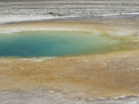
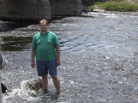
It is my belief that, following this somewhat abortive hike, we once again lunched at Whiskey Flats picnic area, since we were—once again—in its vicinity around lunchtime. After lunch, we decided to check out the Midway Geyser Basin—one of several other collections of geothermal features in the area besides the Old-Faithful-centered Upper Geyser Basin—largely because our impressions of it from what we saw from the trail to Fairy Falls on the previous day led us to believe (quite correctly) that its features boasted lots of bright, vivid color. When we pulled into the parking lot, I knew that I had also found the place where I was going to go wading. The Firehole flows past the thermal features, from which several constantly-flowing streams of steaming water flow down colorful rock and into the river; it (the river, that is) then passes under a little bridge that leads from the parking area across to the boardwalk via which one tours the thermal features. Just past the bridge, the river heads into some nice little rapids, looking all shallow and inviting. Several yards further down, there was, I believe, a fisherman standing in the middle of the stream, and people were enjoying the sun and the scenery on a grassy expanse between the parking area and the river. At least one or two other people were, or had recently been, wading, too. In any case, we walked the boardwalk and marveled at the pretty features, and then I exchanged socks and shoes for sandals and came the closest that I was to come, on this trip, to swimming—and I must say that the cold water felt extremely good on my tired feet.
With that bit of business taken care of, we headed back to our campsite—stopping first at the little store at Grant Village, just outside the campground itself, to again pick up some burgers for grilling. The store also had onions, and the pre-chopped and pre-sliced onions that I’d brought from home having been used up by this point, we wanted to replenish—but realized that we hadn’t brought a knife along with which to slice up an onion. Jen solved the problem by perusing the gift shop part of the store and finding miniature flip-open-style camping knives intended to go on one’s key ring; there was a selection of “personalized” ones with various common names engraved on them, and she found one with my name on it (and the word “Yellowstone” on the other side). We bought it to use on the onion, but of course it also became a souvenir of the trip for me. I cooked the burgers to my satisfaction this time (again seasoning with garlic pepper), and supper was tasty. After supper and cards, we headed over to the amphitheater for another slide show presentation. Getting there a bit earlier this time, we more fully took in the fact that the shore of the lake was right behind the stage of the amphitheater (blocked from view by the screen, but visible to one side); the sun was setting across the lake, and it was absolutely gorgeous. Naturally, we had left the camera in the tent back at the campsite, figuring that it would not be needed at an after-dark slide show presentation. All we could do was hope that nature would repeat the performance the following evening. This evening’s presentation turned out to be about winter in Yellowstone, and as such, naturally appealed to Jen more than it did to me; the parts about how the park’s wildlife copes with winter weather were interesting to me, but the gushing about how much fun Yellowstone in winter supposedly is rather failed to persuade this diehard winter-hater, I’m afraid.