Day Seven (Friday, July 3rd)
Though it was much warmer when we got up in the morning on this, our last full day in Yellowstone, than it had been on any of the previous mornings, this proved a deceptive omen; the weather decided to be iffy at best throughout most of this day. We decided to start the day by trying out the other (i.e. east) end of the Mary Mountain Trail that we had tried the west end of on the previous day. It was a bit overcast as we drove up the east side of the loop and through the Hayden Valley, where, as always, we saw buffalo. When we reached the little pull-off by the side of the road where one parked to access the trailhead, we encountered others who had just come off of the trail we were about to set out on and were warned that the trail was extremely muddy. Undaunted, we set off; a short way down the trail, more people coming back the other way delivered similar warnings. The trail was a narrow dirt rut through open grassland, with a treeline perhaps fifty yards off to our right and up a slight rise, and the expanse of the Hayden Valley off to our left. In places, the dirt was indeed mud, but it was easy enough to step up onto the grass to one side or the other and thus evade the muddiest areas; in fact, enough other people had evidently done this already that there were little alternate paths worn into the grass next to the main path through the muddiest areas. After a time, however, the muddiness decreased markedly, after never having been bad enough to bother us much—so we wondered a little, although I think we both certainly feared that the worst (the part everyone had been warning us about) might be still to come. As we walked, though, we did notice a couple of buffalo quite a ways off in the distance on our left—not close enough to see very well at all, but still, nifty. Before too terribly long, though, our fears were confirmed, as we arrived at an area that was not merely muddy, but in fact extremely marshy. The trail itself became invisible in places, and it became difficult (often flat-out impossible) to find dry ground to tread upon. We were essentially trekking through tall grass that hid varying depths of standing water; our shoes, socks, and feet quickly got very wet, and we were getting mud all over our legs. Still, we soldiered on for a while, trying to pick out the driest footing available. It was pleasantly cool, and there were no bugs today—and I think we both felt motivated to make something of this hike despite the unpleasantness of the terrain. When it began to sprinkle, though, and when the marshy terrain just didn’t seem to be giving way to drier ground, we reluctantly decided that we’d better turn back. It’s impossible to say how far we’d gone, as the going was so slow due to the need to seek out safe places to tread that it took us much longer to go however far we did go than it normally would. It continued to sprinkle intermittently as we made our way back, but thankfully never opened up and started all-out pouring on us or anything.
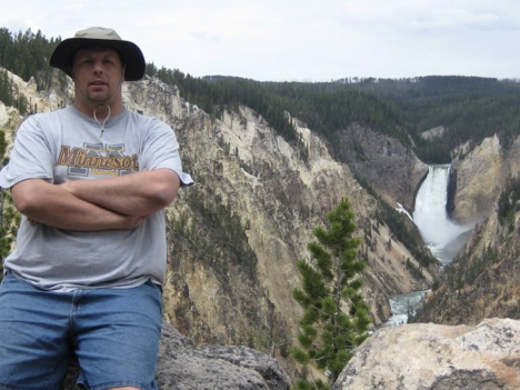
It continued raining intermittently after we got back to the car, so, not quite sure what to do, we headed up the road to the Canyon Village area, to which we were already fairly close. There was talk of perhaps buying rain gear, but it wasn’t actively raining anymore by the time we got there, and we continued to hesitate uncertainly over what to do, given the weather. After perusing the rest of the exhibits in the visitor center that we hadn’t gotten to on Tuesday, we peeked outside and saw that it was not raining and that the sun was possibly coming out. We decided that since on Tuesday we had explored the north rim of the canyon pretty thoroughly, it might be worthwhile, as long as we were in the vicinity, to at least drive along South Rim Drive today; there’s a spot called Artist Point on that side from which a good view of the Lower Falls can be had, and I wondered if that might be where I recalled photographing the falls from twenty-one years ago. So we drove out to the parking lot by that spot, got out, and walked to the observation point (which is just a few steps away from the parking lot). The view was fantastic, but even though it wasn’t raining, it was windy and cool—much cooler than it had been earlier, in fact, so that the shorts & t-shirt outfit that I was wearing was no longer weather-appropriate. In short, I was freezing. Plus—maybe due to the gloomy weather, or who-knows-why—Jen and I were both starting to feel really lethargic and energyless at this point.
There was a particular trail described in our book that I had hoped to get a chance to hike that was over on the other side of the big loop, near the Old Faithful area and not far from several of the other trails that we had already hiked. When we started the day by heading up the east side of the loop, I wasn’t sure if we’d end up making it back around the other side and doing this trail—but at this point, with me underdressed and cold and wanting to go back to the campsite to change into jeans, we figured that if we were going to go that far, we might as well head up the other way and do this hike after the stop to change (unless we were to end up just deciding to skip it due to the weather and/or our general listlessness). We drove back down to Grant, and although there was a certain temptation to just lie down in the tent and take a nap, we resisted it; I exchanged my shorts for jeans, and we resolved to go for the hike. En route to the place where the trail starts, we noticed that nothing looked at all wet over on this side of the loop—as if the rain hadn’t come this way. Also, the sun was coming out and the weather just generally seemed much nicer now (ironically, I really wouldn’t have needed to change into jeans). I don’t recall if we were still feeling tired and listless when we got to our destination or not, but if so, the feeling soon passed once we actually started hiking.
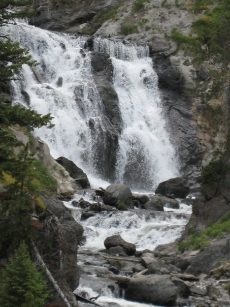
The trail for this final hike of the trip was the Mystic Falls Trail, which began at the Biscuit Basin parking area. Biscuit Basin features yet another collection of geysers and hot springs, and is named for biscuit-shaped formations that used to surround one of the hot springs but were destroyed in the big earthquake of 1959. Our trail branched off from the boardwalk that circles among the geothermal features, so we toured halfway around Biscuit Basin on the boardwalk and then set off on the actual hike. There are several converging and intersecting trails in the area, and the description in our book was a little confusing, but we managed to pick the path that we’d intended to pick. The trail found its way to, and then followed, the Little Firehole River—a tributary of the Firehole River—upstream to the falls. The terrain was rough and rocky, and there was no peaceful little pool at the foot of these falls—so no wading or swimming opportunities—but the scenery was nice and the falls were impressive (I’m a sucker for waterfalls). From the base of the falls, the trail continued steeply upwards, taking us up to the top of the falls for a spectacular view.
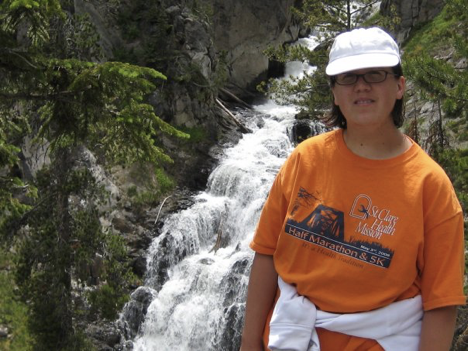
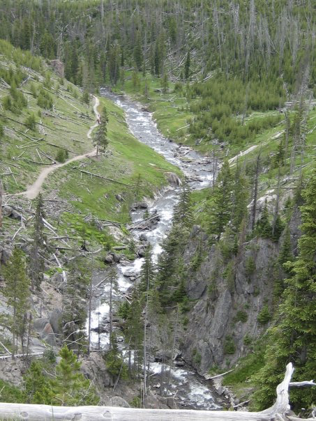
Way back at the start of the trail, there had been a fork; both paths led to the falls, but one was described as being both shorter and more scenic than the other. We’d opted for that one, but essentially, the two paths form a loop, so that by continuing on past the falls, we would walk the “longer” route in reverse and eventually return to the fork. This, then, is what we did. Even after we passed the top of the falls, the trail kept climbing steeply; every time we thought we were finally at the top, we would round a bend and see another steep rise ahead of us. It was exhausting, but in a totally different way from the steep trails in the canyon area three days earlier; I felt totally able to handle all the strenuous climbing today, and I enjoyed the hike thoroughly. There were fantastic views of the whole Firehole Valley around every corner (though I seem not to have taken pictures of them!), and even though dark clouds started rolling in as we were nearing the top, and thunder could be heard rumbling off in the distance, the rain held off, so that our final hike of the trip turned out to be really fun all around. Eventually the trail did stop climbing and start descending in a long series of switchbacks. As we went down, we encountered several groups of people heading up the way we had come, and most of them asked us how much farther it was to the falls (apparently they’d all chosen the “long” way, whether intentionally or not). A group that we met when we had barely started descending yet was happy to learn that although the falls were still a ways off for them, it would be mostly downhill from there. A couple whom we encountered after we’d gone down quite a ways was rather more dismayed when we broke the news that there was still quite a climb just to get to the top, and even then, they’d still be some ways from the actual falls! (The wife was leaning toward turning back, but the husband, who wanted to keep going, assured her—despite what we’d just told them—that they were “almost there.” As we went on our way, we heard the wife dismissing this assertion because, she said, she trusted us, and declaring us her “new best friends.”)
After our hike, we went back to Grant and grabbed a quick dinner at the Grant Village Grill (fast food, more or less), since it was looking pretty serious about starting to rain again sometime soon—so we figured trying to get a fire going was probably just not worth it. After eating, we did a little souvenir shopping in the store there, and bought gifts for the friends who were kindly looking after Andante for us while we were away. I don’t remember exactly when, but it did start raining at some point, and we ended up playing cards in the tent again; so much for our hopes of catching another sunset over the lake by the amphitheater! As it got later, it only started raining harder, and a minor leak or two appeared in our tent, causing some things near the sides of the tent to get a bit wet. This led Jen to start contemplating wild ideas like packing up and hitting the road for home immediately, rather than spending the night in what seemed like it might become an ever-wetter tent. Given the prospect of taking down and packing up in the rain, though, and realistically considering that we would no doubt get tired pretty quickly if we tried to drive through the night—not to mention the fact that there were still a couple of things that we were planning on stopping and seeing on our way out of the park the following morning—this idea was quickly quashed. Fortunately, the leaks were only minor, and we stayed reasonably dry through the night.
Day Eight (Saturday, July 4th)
Given the night’s rain and the fact that we’d be packing all the camping gear up wet, we weren’t too keen on the prospect of setting it all up and sleeping in it again for one more night, so we got up bright and early this morning (5:30) with the idea of seeing if we could make it all the way home in one day. Barring that, there was talk of finding a cheap motel to spend the night in should we reach a point where we were both too tired to drive—but we were both pretty set, I think, on making it home today; the idea of having a day at home to unpack, collect Andante, do laundry and groceries, and etc. before having to go back to work was very attractive. We did still have a couple of stops planned on our way out of the park, but we didn’t intend to dawdle. It took us just over an hour to get all packed up and ready to go, and we were on the road by 6:40 am (Mountain Time, of course). It was foggy in the park as we headed north, and there wasn’t much traffic this early in the morning. There were, however, buffalo to contend with in Hayden Valley; we stopped to let one cross the road in front of us, and a few minutes later, we came up behind a stopped vehicle; Jen, who was driving, wondered aloud why we were stopping, and then I spotted a great big buffalo sauntering down the road in the middle of the other lane, with oncoming traffic waiting behind it!
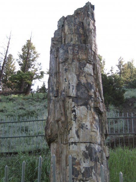
We had noticed early on that there was a spot up in the northern part of the park marked on the map as having a petrified tree. Since we hadn’t gotten to see the petrified forest at Theodore Roosevelt National Park, we wanted to make sure we found time at least to see this single petrified tree, but since it was way up in the northern part of the park, it would have been quite a drive to go there and back from the campground. Thus, we had decided to stop and see it on our way out of the park. It was about ten after eight when we got to the pullout by the side of the road, from which a short sidewalk with a few steps led to the spot. We read the sign (which said that the tree had been a redwood—quite out of place in modern Yellowstone!), took a picture, and were on our way.
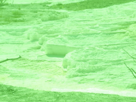
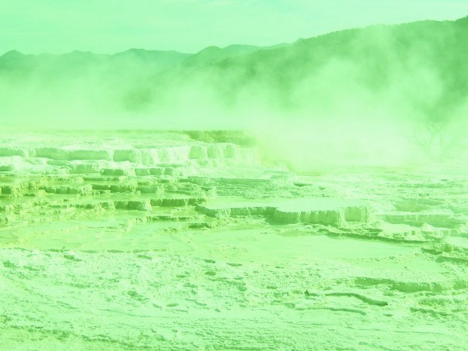
The other stop that we wanted to make was at Mammoth Hot Springs, which is just south of the park’s north entrance (via which we planned to leave the park). There’s more to see and do at Mammoth than a brief stop on the way out could possibly do justice to, I’ve no doubt, but again, it was a place that we couldn’t really get to from Grant without killing hours and hours on the road. I had to at least pay a quick visit, though, once I’d read that the springs there form “travertine” terraces; I’d never heard of “travertine,” but the pamphlets said that it’s composed of calcium carbonate, so in essence, it’s a form of…that’s right…limestone. We took a quick spin around the Upper Terraces (there was a one-way loop drive), stopping once to take a few pictures. As I fully expected—and as my totally non-doctored photos prove—the “travertine” terraces were, of course, bright green.
Following this stop, we headed due north, reaching the park boundary and saying our goodbyes to Yellowstone around 10:00 in the morning. Highway 89 took us from the park boundary to I-90, and before we knew it, we were racing east along the interstate. We had lunch at Taco John’s in Billings, then drove all afternoon, making it back to Dickinson, SD for a somewhat early dinner at Arby’s. We also filled up on gas in Dickinson before setting off across the length of North Dakota. There was talk of whether we ought to fill up again in Bismarck, but we still had plenty of gas at the time, and having just stopped in Dickinson, we were anxious to make time. Besides, we remembered having fueled up in the small town of Medina on the way out, and we figured we could do the same today. What we were forgetting, however, was that the bridge over the interstate on the road leading into Medina was torn down and being rebuilt. This hadn’t been a problem on the way out west, because the town lies north of the interstate and is thus accessible from the westbound exit ramp. Going east, however, you can exit, but you can’t actually go into town once you’ve done so, because there’s no way to get across the freeway.
We were getting fairly low on gas when we got to the Medina exit, so when we realized that we couldn’t stop for gas there, we began to worry. The next sizable town we would come to would be Jamestown, ND, but we weren’t sure exactly how far it was and weren’t entirely confident of making it before running out of gas. A short way past the Medina exit, there was another exit labeled as a detour route for Medina; the idea was that you could exit there, then get back on the interstate going west, so that when you got back to the Medina exit, you could take the westbound exit and actually be able to get into the town. For one reason or another, however, we failed to take this exit. Partly, I think, we were just figuring out what it was about at the last minute, but I think too that I was partly to blame, as I think I was misreading the map and thinking that we were closer to Jamestown than we really were, so I hadn’t started worrying quite enough yet. That soon changed as I looked at the map more closely and we started to realize that we might really be in trouble. Then, at the exit for one of the next couple tiny little towns—it was either Cleveland or Windsor, I forget which—there was a sign advertising that gas was available off the exit. Cautiously relieved, we took the exit and headed down the country road into town—though it occurred to us, as we did so, to wonder whether the gas station in this middle-of-nowhere spot would a) be open on the evening of the 4th of July, or b) have credit card readers on its gas pumps. These worries proved well-founded, as the tiny little one-pump gas station, which was very old-fashioned-looking, did indeed prove to be closed and to lack credit card readers. Moreover, just as we were discovering this, the car’s “low fuel” light came on. We weren’t entirely sure, at this point, whether it was closer to press on to Jamestown or turn back and head to Medina, but if anything, Medina seemed the closer destination—so, not wanting to take chances, we decided to head back there. In retrospect, I’m not sure that was the right decision; I’m pretty sure, now, that we would have made it to Jamestown just fine if we’d gone on, and although we were pretty sure we remembered the gas station in Medina being a more “normal” one, surely Jamestown would have been a better bet for finding a place to get gas after hours on a holiday. If we’d gone back to Medina and been unable to get gas there, however, we probably wouldn’t have made it to Jamestown afterwards—so the more I think about it, the more foolish our decision seems as I look back on it. In any case, though, it turned out that we were able to get gas in Medina—though it looked iffy for a moment. The gas station was closed, and the pumps were old, non-digital ones—but a separate, free-standing unit had been installed next to them, unlike anything I’ve seen anywhere else, that accepted credit cards. It was a little tricky to figure out, but it worked—and we got our gas. That done, we then drove around a bit in the hope of finding a back road leading east to the next freeway entrance, but none of the streets that looked like they might possibly lead somewhere out of town were labeled at all, so we gave up and resigned ourselves to getting back on the interstate heading west, then getting off and turning around at the first exit we came to. Such was our adventure with trying to get gas in (or near) Medina, ND.
As we pushed on into eastern North Dakota, the sun set behind us, and we started to see fireworks displays off in the distance ahead and to either side. We pulled off the highway in West Fargo around 11:00 pm to switch drivers for the last time, and as Jen proceeded to doze off, I drove us back into good old Minnesota and the rest of the way home. We did need gas one more time on this final leg of the trip, but being back in familiar territory (not to mention a much more densely settled area), I knew plenty of places where it could be gotten; I made the stop at the Trucker’s Inn in Sauk Center, where we used to stop quite often back in our Morris days. It was around 2:00 in the morning when we reached the metro area, and nearly 2:30 by the time we finally pulled into the garage at home sweet home. It had been an amazing trip, but now it was over.