I suppose there wasn’t really anything overtly “charmed” or “cursed” about my first full day in the park, unless I wanted to argue that in some respects, each individual portion or aspect of the day kind of felt like it combined a little bit of both. But maybe that’s just another way of saying that it was really neither.
My first order of business, after dragging myself out of the warmth of my sleeping bag and out into the cold morning (and getting some breakfast in me), was that visit to the back country office. Of course, when I got there, I learned from signs posted around that both it and the main visitor center were closed. It turns out that Yellowstone has yet to fully emerge from pandemic times. Don’t ask me why the stores and gift shops are able to operate normally but the visitor centers and back country offices can’t be staffed; it doesn’t make much sense to me. Even before finding that the office was closed, I had been a bit concerned about how I was going to acquire my permit, because… But wait, I should back up. I told lots of people about my plans before going, but some readers may not be among them, so: My big ambition for this trip was to do a two-day hike where I camp overnight at a back country campsite. I’ve done my share of back country hiking on past trips out there, but they were always day hikes; I’d never done an overnight backpacking adventure before. (This was partly because I’d never been sure if I even wanted to, but also partly because prior to acquiring a small, potable battery for my C-PAP machine last year, it wouldn’t really have been possible for me.) Anyway, you have to let the rangers know your plans and get a permit in order to camp overnight in the back country (and also to ensure that the back country campsite that you intend to stay at has not already been claimed for that night…although the number of people who actually do this is small enough that this isn’t usually much of an issue). So as I was saying, I was already worried because the park’s website says that you have to apply for back country permits by either phone or email (not in person). But it also says you can’t apply more than three days before the date of your hike, which meant that I couldn’t do it from home before the trip. And of course, there’s no cell or internet service throughout most of the park, so how was I going to apply via phone or email once I was there? (In theory, I could have done it from the Bismarck KOA on Sunday night, but I didn’t. I also kind of wanted to wait and talk to a ranger in person, learn any relevant facts about trail conditions, etc., before making a final decision about which of two possible hikes I was even going to do.) Fortunately, even though the office was theoretically closed, there was a ranger in the vicinity (mainly on hand to do mandatory boat inspections for people wanting to go boating on Yellowstone Lake, I think). This ranger, whose name was Ethan, became my new best friend. He wasn’t able to help me directly due to various technological and bureaucratic obstacles, but I learned from him that “no cell service” actually depends on which provider you use; I had no signal, but his cell phone did, and he let me borrow it. So I called some other ranger who was somewhere else, and (after leaving a message and waiting around for him to call me back via the helpful Ethan’s phone) that ranger was able to issue me my permit, although I had to make a makeshift hard copy by writing the permit number and all the other info down on a scrap of paper since I wouldn’t be able to access an emailed copy. Long story short: It all worked out, but it took up half my morning, which was frustrating, as I had actual Yellowstone fun planned for the day and wanted to get going on it lest I run out of time. (See? Both charmed and cursed.)
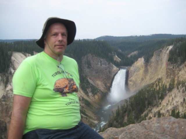
Almost all of the things that I planned to do at Yellowstone during this trip involved locations generally along the southwestern third or so of the southern loop road (i.e., between West Thumb and Madison). This was partly fortuitous, but also at least somewhat purposeful, with the idea of not spending too much of my time in Yellowstone in the car, driving to far-flung parts of the park. However, this first day was the one exception. I couldn’t go to Yellowstone and not take in the Grand Canyon thereof, with emphasis on the lower falls; to do so would practically be a crime! Plus, there was a hike in that vicinity that I really wanted to do…but that would wait for the afternoon.
Honestly, I almost don’t really know what to say about my half-morning of canyon-area sightseeing. I’ve been there before and written about it before, multiple times. It doesn’t get any less mind-blowingly gorgeous with repeat visits, but it does become rather harder to find new things to say about it. On the other hand, the new thing about me that I already began suspecting as I huffed and puffed my way back up each steep canyon trail after descending and taking in the views was: I think I’m getting old! I mean, those trails have always been strenuous on the way back up…but they seemed even harder this time than I remember them being the last few times (even if still probably easier than back in 2009 when I was at my heaviest and most out of shape). And sure, I’m fatter again now than I was in 2014 or 2016, but I ought to be in better shape than I was on my last trip in 2018, in light of my exercise habits then vs. now. But of course, I am three years older. One foot in the grave. A geezer. Etc.
In any event, here are a bunch of pictures (I’m just gonna go nuts here and include most—though still not actually all—of the ones that I took on this morning):
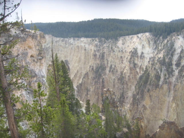
Canyon Scenery From “Lookout Point” (My First Stop) 
More of Same 
Quintessential Lower Falls Shot 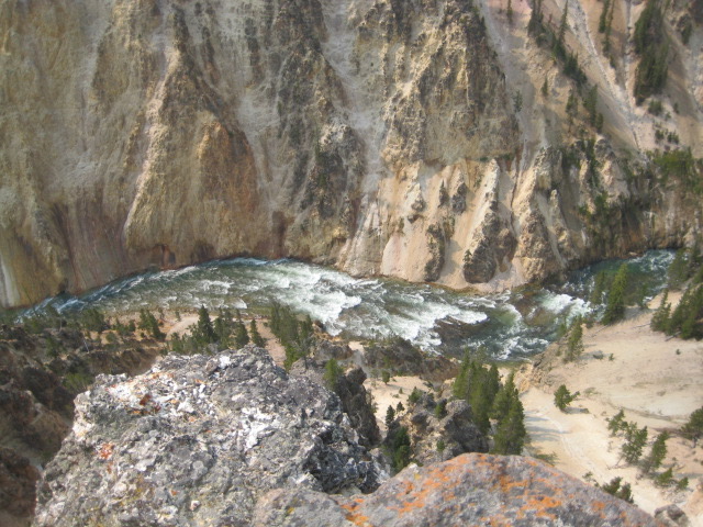
Looking Down Into the Canyon 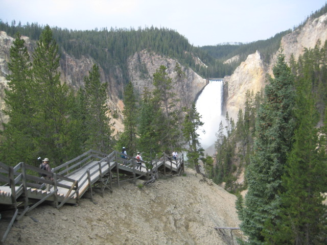
Part of the Trail Down from Lookout Point to Red Rock Point (Lower Falls in Background) 
Canyon View Blocked by a Random Tree 
Classic Shot of the River Winding Away Through the Canyon Below the Lower Falls 
The Brink of the Lower Falls is my favorite canyon spot, but it’s more about being there than about photographability. 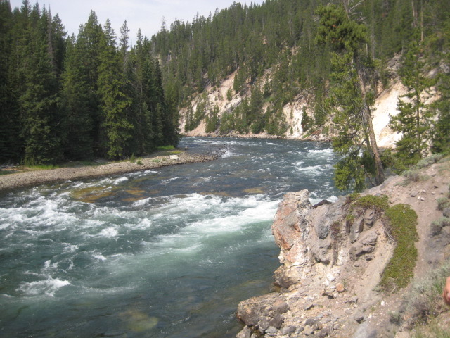
Looking Upriver Just Above the Lower Falls 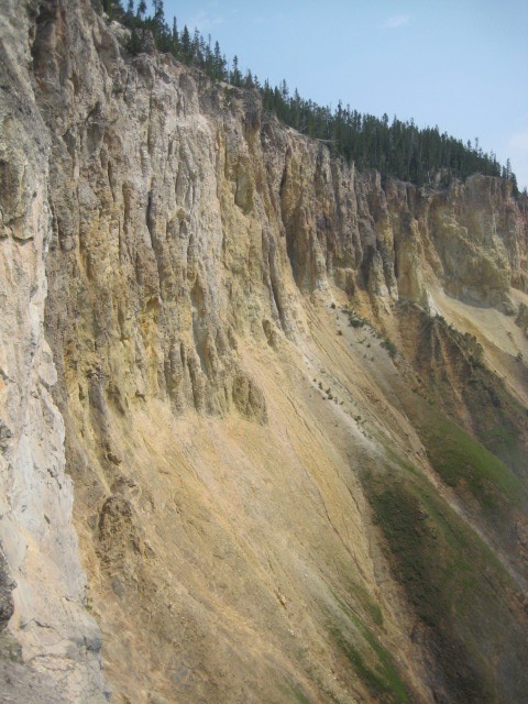
Canyon Wall 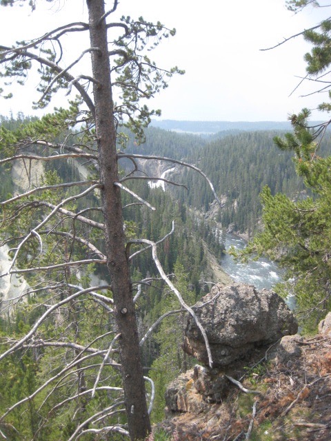
I didn’t take the time to visit the Upper Falls up close this time, but they appear in the background of this photo. 
Another Canyon Shot 
And Another 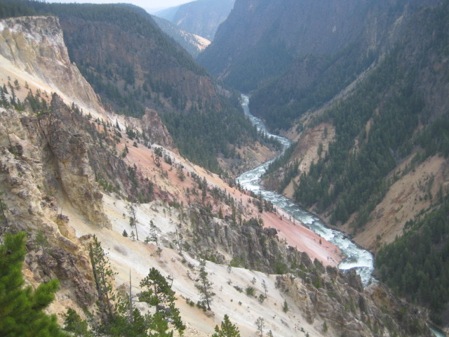
And Then Another 
And One More

All of these pictures were taken from various vantage points along the canyon’s north rim; I didn’t visit any of the south rim spots this time around. My time was limited, since half the morning had been eaten up by the permit-acquisition business and I wanted to get my first full-on hike in after lunch. As a result, even though I enjoyed the views as much as ever, I felt a bit rushed throughout my morning of sightseeing, wanting to do more than time really allowed but also kind of not really committing to anything in particular. Ah, well. I still have fond memories of engaging more fully with this area (hiking portions of both rim trails and trying to photo-document the whole length of the river through the area, even if partial trail closures thwarted that project a bit) back in 2016.
On the other hand, the last few of the photos above were taken from Inspiration Point (the farthest-out of the spots along the north rim that are accessible by car), which I’m not sure I’d ever actually gotten to on any of my previous trips. (I recall that in 2018, when touring this area with my parents and my nephews, the road out to this spot was temporarily closed.) However that may be, it was extremely lunchtime by the time I left Inspiration Point, so I headed to the parking lot just across the Chittenden Bridge, on the other side of the river and canyon (lower left on the map). This parking lot serves both the Wapiti Lake picnic area and the trailhead for my afternoon hike, so it was obviously the place for me to be!
Every one of my trips to Yellowstone (beyond the first) is, among other things, a do-over, giving me an opportunity to do things that I had wanted to do on past trips but was unable for one reason or another. I’ve written before, for example, about how I got to wade into the pool at the foot of Fairy Falls in 2016 (something I’d regrettably not come prepared for in 2009), and how in 2018 my brother Carl and I conquered the Mary Mountain trail (which I’d been yearning to hike for years), and that same year I also finally got to swim at the swimming spot on Firehole Canyon Drive (closed on previous trips). (I would attempt to repeat two of these things on this current trip, but would only succeed at one of them. Stay tuned!) Well, on my 2016 trip, I started a hike from the Wapiti Lake trailhead that got cut short when I came to a split in the trail where the fork that I was supposed to follow turned out to be closed off for some reason (“something about wildlife protection” was what I recorded as the explanation when I wrote about it at the time). Time to redress another previously thwarted Yellowstone adventure! This hike, to Wrangler Lake, goes through buffalo country (I had been keen to hike with the buffalo in 2016), and also involves a river ford (another obsession of mine) that my hiking book describes as “exciting” and (if attempted early in the season, anyway) even “a precarious waist-deep adventure” (!). I wasn’t sure what the ford would be like in mid-July, but I figured I would find out when I got there.
Soon after I set off on the hike (which was to be 10.2 miles total: 5.1 miles to Wrangler lake, then turning around and retracing the same path back to the trailhead), I again found myself feeling like I must be getting old. Yes, the first little bit of the trail was an uphill climb…and sure, I had already tired my legs out a bit climbing up steep canyon trails that morning. But five years ago, I had done the exact same thing (I’m only now realizing how 100% true this is; revisiting my account of that trip, I see that I had gone to both Red Rock Point and the Brink of the Lower Falls right before starting this same hike…the same two steep trails that I had walked this morning!), and I don’t remember the start of this hike as being unduly strenuous that time. In fact, I wrote afterwards that I had “immediately liked” this trail, and recalled that up until encountering the closure at the fork, I had been “hiking along and reflecting on how utterly content I was feeling, while at the same time eagerly anticipating what later portions of the hike had in store for me.” Today, however, I was huffing and puffing my way along, barely able to hack it! Hmm… (I considered cutting myself some slack by reflecting that this was day one of my trip, and maybe I hadn’t acclimated to the elevation yet. However, again looking back to 2016, I spent the morning of day one on that trip traipsing all over the Old Faithful area and then did an 11-mile hike that afternoon, and I’d loved every minute of it. Sure, that hike was mostly on flat terrain…but still!)
After a while, though, the trail leveled off and I kind of found my stride, and I started enjoying myself. It wasn’t long, either, before I encountered one of the things that I had been specifically hoping to encounter on this hike:

Nor did it take me long to reach the fork in the trail where I had ended up turning back last time. (The other path, which had not been closed that time, led into terrain that I was less interested in hiking through.)

After that, the trail kind of alternated between buffalo prairie type terrain and more wooded areas, which was kind of cool. There was also a stretch where the telltale scent of sulfur in the air and a glimpse of whitish ground through the trees off to my left revealed the proximity of a back-country thermal feature (presumably a hot spring or fumarole). Classic Yellowstone stuff.


In due course, I came to the first of the two creeks that my book mentioned having to ford. This one (which I seem not to have photographed) was just an unnamed tributary of the other, larger one, but even it, says my book, “may be a hefty ford in early season.” Well, it wasn’t. It was barely even worth changing into water shoes to wade across, in fact. If I’d tried, I might have been able to get across via a log that was just downstream from where the trail met the creek, or even by jumping out onto a little sand bar and then the rest of the way across from there. But instead of doing either of these things, I went ahead and waded across. From there, it wasn’t far at all to the “precarious waist-deep adventure” creek, which…was only slightly deeper than the first one, and not an exciting challenge at all. 🙁 I guess I would have needed to do this hike in June if I wanted adventure fording.

The destination of this hike, Wrangler Lake, was actually the least appealing thing about it, at least based on the description in my hiking book, where it is described as a “mosquito-breeding haven.” Obeying the book’s advice, I approached it warily, insect repellent at the ready. However, it may be that I now experienced the up side to it not being “early season” enough for the creek to be very impressive; the area near the lake didn’t seem any buggier than anywhere else.


On the return hike, I again felt the physical exertion wearing me down a bit, and enjoyed myself somewhat less than on the hike out. I mean, it wasn’t horrible, by any means. On level ground, or when going downhill, I was basically fine, if a bit tired. But it seemed like it only took the slightest little upward incline to leave me gasping for breath and my legs begging for a respite. Some concern flashed through my mind, at these times, as to how I was going to fare when I embarked on my big two-day hike carrying all my overnight gear on my back. But that was a “tomorrow” worry; for now, I just pressed on. Upon passing again through that fork where the trail closure had defeated me five years ago, I gloated aloud: “Wrangler Lake trail, conquered!” And then, before long, I found myself looking down a modest hill toward a line of trees that I recognized, and beyond which, I knew, lay the parking lot and my car.

All that then remained to my day was a tired drive back down to Grant, the building of a fire to cook my hobo dinner that I had prepared at home and saved in a ziplock bag in my cooler for this night, and some campsite relaxation and face-stuffing.