If I had begun to suspect on Tuesday that I might perhaps (gasp) be getting old, Wednesday morning provided more evidence pointing toward this conclusion. I found (not for the last time on this trip) that following the exertions of the previous day, I did not bounce right back after a mere decent night’s sleep and feel ready to tackle my next Yellowstone adventure first thing in the morning (as I have typically done on previous trips). Fortunately, it had also occurred to me the previous evening that this was actually okay. Today was supposed to be the day when I would set off on my two-day hike, but there was really no need to hit the trail bright and early. The entire hike would be approximately 18 miles, but that would be split over two days. The distance from the trailhead to the campsite where I’d be staying tonight was listed in my book as 10.6 miles. Depending on assorted variables (the nature of the terrain, how much carrying a ton of gear would slow me down, how much I dawdled, etc.), I figured I could probably hike that distance in four or five hours. If I got going at like 8:00 am, that would get me there in the middle of the day, leaving me a lot of down time in the middle of nowhere (and necessitating bringing that much more food along). So, from that perspective, I decided that I could afford to spend the morning relaxing and recuperating at my “base camp.” Thus, when I woke up this morning, I spent a few hours lying in the tent and reading, then eventually got up and had a leisurely meal that we’ll call “brunch.”
It was probably noonish by the time I got started packing all my gear into my backpack in preparation for the big hike. In my initial test-packing at home several weeks earlier, I had struggled to find a way to include everything that I wanted to bring, and had even contemplated having to omit the miniature inflatable sleeping pad that my brother Ted had lent me. Later, when I’d revisited the problem while packing to leave from home at the start of the trip, I figured I would just attach it to the back of my pack with a bungee cord. But now, happily, I discovered an additional set of straps on the back of my pack that I had somehow overlooked before, which eliminated the need for jury-rigged bungee cord solutions. (Part of the challenge here was that in addition to all the things that you might expect me to be packing—tent, sleeping bag, sleeping pad, food, warm clothes, rain jacket, etc.—I also needed to lug my CPAP machine with me if I expected to get any sleep tonight.) Also, while getting everything packed and ready, I had a brilliant idea: Previously, I would always store water bottles in the side pockets of my backpack, where in theory I could access them without having to take the pack off and open it up…but in practice, reaching around to extract a bottle from one of these pockets with the pack on was always difficult (to say nothing of stuffing it back into the said pocket afterwards). Plus, with the amount of stuff coming on this hike, there were other contenders for side pocket space—though it helped that I would only need one water bottle for this trip, since I had purchased a new one with a filter that meant I could refill it from streams along the way. But this nifty new water bottle also had a loop with a carabiner attached to it. What if I had a lanyard to put around my neck, and attached the water bottle to that? Clearly, I needed to stop at the Grant Village general store/gift shop to pick up a lanyard before driving to the trailhead!
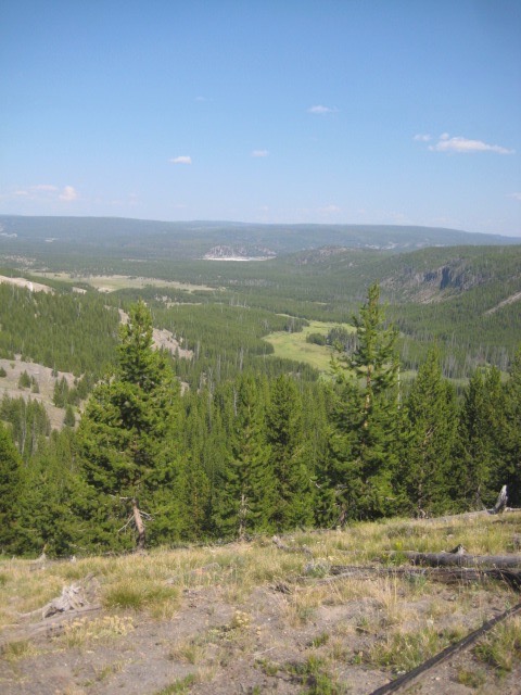
In the planning stages of this trip, I had identified two possible trails for my two-day backpacking adventure, and had left it up in the air as to which one I would ultimately go with. I also had the idea that maybe I could do whichever hike I didn’t choose as a long day hike later in the week. One of my two candidate trails, though, was one that my trusty Yellowstone hiking book doesn’t actually cover; instead, I’d found info about it online several months ago. But, genius that I am, I had only saved the link to the said online info on my laptop, not the info itself. Without internet access, this wasn’t too helpful! This needn’t necessarily have been fatal, of course; I could probably have inquired with Ethan the ranger the previous morning and gotten info about the trail in question, for instance. But I had already felt like I was imposing on him enough at the time (while he was simultaneously busy trying to manage various other things), and in any case, this trail (whose total length, at least, I had made note of) was supposed to be about a mile shorter than the other one, so there was an argument to be made that if I was going to maybe do one of them as a day hike, it should be that one. So, when acquiring the back country pass yesterday morning, I had made my decision. This “other” trail, which would have taken me to the Shoshone Geyser Basin (“the largest backcountry geyser area in Yellowstone”), sounded awesome, but maybe I could still track down a ranger, get info about it, and hike it on Saturday—and if not, oh well. For my two-day backpacking extravaganza, though, I would be hiking the Fairy Creek trail. It’s a big loop (sort of) that begins at one trailhead and ends at another one that’s a couple miles down the main road from it (so the final 2.3 of those ~18 miles would be along the shoulder of the road, unfortunately). The first section is the exact short hike to Fairy Falls that Jen and I did together back in 2009, and the last section (apart from the road portion) is a hike to (or in this case, back from) Mystic Falls, another lovely waterfall that Jen and I hiked to in 2009. In between these sections is a long trek through more remote country that far fewer people ever visit (though not none, of course; there are, after all, a couple of campsites available out there, and a well-marked trail the whole way).


After picking up that lanyard, I drove up to the Midway Geyser Basin area (which is where Grand Prismatic Spring, the largest hot spring in the park and one of the largest in the world, is found). At this point, naturally, I came face to face with the two main down sides of my “don’t get started until afternoon” approach: it meant struggling to find a place to park near this very popular attraction and then dealing with large crowds of people before getting to the actual trailhead, and it meant starting my hike during the hottest part of the day. Even though I had (as noted) hiked the first part of this trail 12 years ago, I had no very clear memory of where the trailhead was from the parking area, and on top of that, I ended up parking in an unpaved “overflow” parking area to the south of the (stupidly small) “regular” parking lot. There were people everywhere, and I felt a bit ridiculous walking among them with my enormous pack on my back—all the more so, of course, given that I wasn’t even 100% sure I was in the right place to get to the trailhead. Also, that pack was….heavy. I mean, like, really heavy.
I left my car behind at about quarter to two in the afternoon. After making my way out of the parking areas and approaching Grand Prismatic Spring, I came upon a sign indicating where the different paths in the immediate area led and how to get to my actual trailhead, so that helped. There was an initial path (my book calls it the “Fairy Flats Trail” that leads kind of around behind Grand Prismatic, and a place where a short trail led off from this to some kind of scenic overlook (which I passed by), and then I finally came to my “actual” trailhead. (I’ve described this hike as being “about” 18 miles, in part because I’m not sure how much of this initial portion the author of my hiking book may or may not have been including in his 17.9-mile figure.)
When I finally turned off of Fairy Flats Trail and headed into the woods, leaving the worst of the crowds behind and not feeling so out of place with all my hiking gear, I quickly transitioned from feeling kind of unsure about this whole endeavor to a state of hiking bliss. To be clear, there were still a fair number of other people about at this point (the trail to Fairy Falls seems to be increasingly popular)…just not crowds of them anymore. I would be alone, and then pass a party of people coming back from the direction of the falls every few minutes (or sometimes less).

I had been to Fairy Falls twice before (in 2016 I got there via hike #78; see trail map above), and on neither of those occasions had I had the spot to myself—but even so, I was surprised at the number of other people who were out there today. (It’s about two and a half miles out to the falls, and they aren’t exactly one of the park’s more publicized and well-know attractions.) I won’t say that it was “crowded,” but there were probably two or three dozen people enjoying this unbelievably picturesque little spot. Until I arrived, however, none of them (it seemed) were actually wading out into the pool at the base of the falls. Grinning inwardly at the memory of my jealousy, twelve years earlier, as I had watched a young woman venture into the water here while I cursed myself on the shore for not bringing appropriate footwear that would have allowed me to do the same, I doffed my pack, changed into my water shoes, and stepped into the pool. After filling my filter-equipped water bottle and enjoying a refreshing drink, I starting taking pictures (and getting as close as I feasibly could to the actual falls).


Soon after I started playing in the water, other people started following my example! First there was a woman who waded in barefoot, which again called forth memories of denying myself a wade into the pool here in 2009 precisely because I judged the rocky bottom too treacherous for bare feet. I guess she was braver than me in this regard. We exchanged greetings as she was wading in while I was wading out. Later, a young guy who had been the next person to venture into the pool actually approached me as I was drying my feet off and putting my socks and shoes back on, and said that I had been his “inspiration”! And another woman (who did not, herself, go wading) remarked to me that I was “the only smart one” who had thought to bring water shoes. Again chuckling inwardly, I replied that I had been here before and thus knew ahead of time what I was going to need when I got here. “Ahh, experience,” she nodded.
Eventually (and somewhat reluctantly), I re-shouldered my pack and left Fairy Falls behind. My reluctance was not, at this point, about the heavy pack or the resumption of the hike; it was just about leaving this awesome spot. In fact, for perhaps the next hour or two, I continued to thoroughly enjoy myself. Believe it or not, for a while I actually seemed to sort of forget about the immensely heavy pack on my back, and I was just thrilled to be where I was and to be doing what I was doing. The scenery was beautiful, the weather was perfect, and I felt full of energy. (I predicted to myself that upon leaving Fairy Falls behind, I might not see any more other humans for the remainder of the day—or, if I did, at least not very many. I’ll bet no more than three separate parties, max, I thought to myself. And sure enough, I encountered exactly three other parties during the ensuing few minutes of hiking, and then no one for the rest of the day!

Not far past Fairy Falls, there’s an unmarked fork where a side trail makes a short detour to a couple of back country thermal features. I remember detouring to check these out on my 2016 hike, but my recollection was that they didn’t make much of an impression at the time. Today, though, they seemed extremely cool to me! (Well, if I’m going to be literal about it—and anyone who knows me, knows that I probably am—they were actually hot.) I dawdled for a while in their vicinity, taking both pictures and a couple of videos.


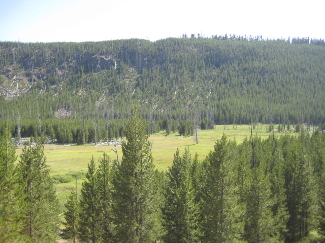
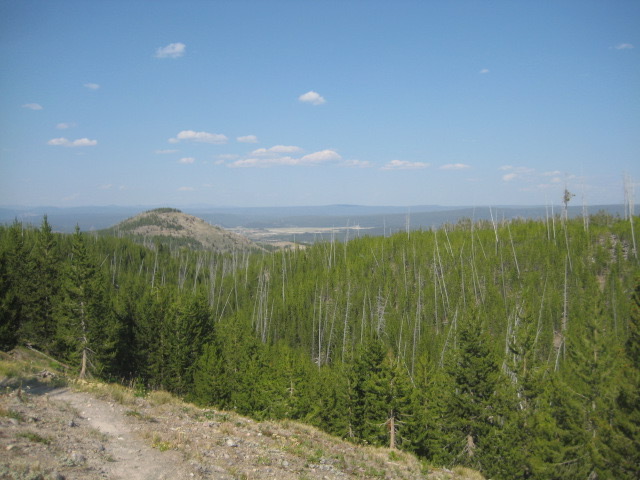
Beyond these two nifty geysers, my book warned me that the trail “climbs steadily for about 4 miles . . . up onto a small ridge.” Gulp. But weirdly enough, for a good while I continued to enjoy myself thoroughly and to feel entirely up to the challenge, even as I began winding along switchbacks up the side of the said ridge. It was strenuous, sure, but I was still “in the zone” in some weird way, such that the weight on my back didn’t feel all that bad, and I wasn’t even breathing heavily like every little uphill stretch had had me doing the day before on the Wrangler Lake trail. Maybe I really was just acclimating yesterday, I mused. Whatever the explanation, I felt on top of the world.


Around the point at which it seemed as though I must have reached the summit of the climb, I stopped for a rest, sitting on a fallen tree or a large rock or something of the kind. I dug out my bag of peanuts, sipped liberally from my water bottle, and just relaxed. I even did a little reading! Having finished one book the other day, and being without my Kindle, and not having anything else suitable at hand, I happened at this point to be working my way through a non-fiction book that my therapist had recommended to me, and that had become available in response to my library request shortly before I left home. In the present context, it felt sort of like I was doing some kind of adventure therapy, or…I dunno, like I was pretentiously trying to emulate Thoreau: disappearing into the wilderness to get in touch with myself and become more self-reliant, or something. 😀
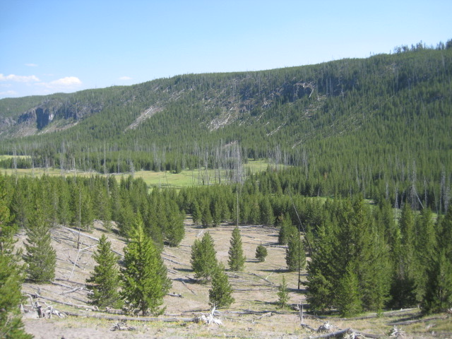
Unfortunately, when I resumed hiking after my rest, my energy and enthusiasm started dissipating at an alarming rate. For one thing, it turned out that I was not done with the climbing. Or at least… Well, my book said that there would be a mile or so of fairly level terrain after the climb, followed by a gradual descent leading to the area where my campsite would be found. And while I was no longer continuously climbing, there was enough uphill-ness that it wasn’t at all clear to me whether I was still in the “climb” portion or had reached the allegedly more level portion. This also meant not having much of a sense of how far I still had to go, which, in combination with my growing fatigue, kind of started to grind me down. Plus…well, I guess I haven’t really conveyed yet how much I had been loving, up until now, both having a water bottle with a filter (meaning I could quench my thirst more freely than on other long hikes in the past, since I wasn’t limited to only as much water as I had started the hike with), and having the said bottle on a lanyard around my neck (so that I didn’t even have to stop walking—much less grope around awkwardly for my pack’s side pocket, or potentially even take the whole pack off—to take a drink). This was totally awesome! But by this point in the hike, it had been some while since I had seen any water sources, so my bottle was nearly empty and I was feeling rather parched. Now the uphill stretches were killing me again, like yesterday, only worse. And that pack? Yeah, now it felt like having a three-ton anchor hanging on my back. The worst moment was when I came, at a point when I felt that by now I surely must be well past the arduous uphill section, to a stretch of trail that (while not long) went up just a ridiculously steep incline (like, any steeper and it would have been closer to rock-climbing than to hiking). Hauling myself up that rise felt next to impossible. Nearly every part of me hurt, by now, and I felt that if the uphill crap didn’t end soon, I didn’t know how much more hiking I could take. When I got to the top of this stupidly steep little rise, I discovered that there was an equally (and treacherously) steep descent to navigate on the other side. So was this just a flukish little hill that my book hadn’t bothered to mention, interrupting what it considered to be the level portion of the trail atop the ridge? Or had that literally been the top of the ridge, and was I (short steep descent notwithstanding) only now beginning the mile of level terrain? Argh!
I had started to lose track of the passage of time by this point, and some of the details have already become fuzzy, too, so even now it’s hard to say where I was or how far I still had to go. I do think that this general “not fun anymore” portion of the hike dragged on for well over an hour, though. Walking became increasingly painful, as I had developed a blister on the bottom of one foot and had seemingly messed up my achilles tendon in the other foot. (When I eventually took my shoes off after reaching my destination, I found that the painful area just above my heel, behind my right ankle, was rather swollen. It still isn’t entirely back to normal even now, almost two weeks later.) I realized, during this stretch, that my notions about possibly still doing the long hike to the Shoshone Geyser Basin later on this trip (as a day hike) were not realistic, which was kind of depressing on top of everything else. But mostly I was just tired and thirsty and hot and in pain and really, really, really ready to be done hiking for the day…especially uphill!
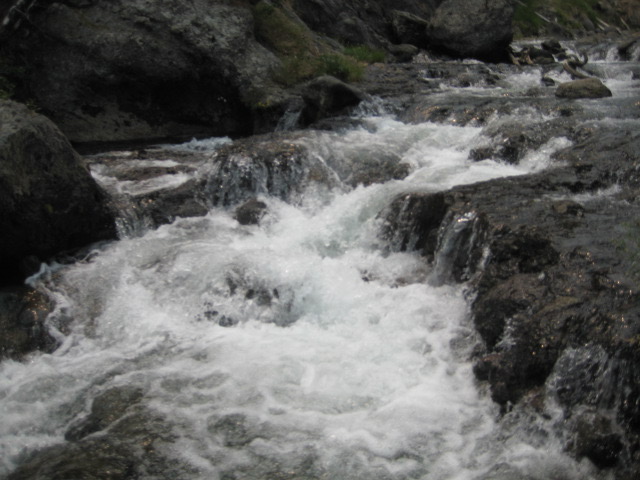
Whatever the truth was in regard to when I got through what my book called the climb portion, when the allegedly level portion started or ended, etc., I have to say that the ensuing “gradual drop” portion must have been…extremely “gradual.” Without ever having been particularly conscious that I was going downhill at all, there came a point when I started hearing moving water somewhere semi-nearby (a hopeful sign!). Then, quite unexpectedly, I came upon what appeared to be a fork in the trail, marked by a signpost. Huh? Oh! The signpost was there to label a campsite! This was not my campsite, yet; it was site OD2 (see trail map from earlier in this post), whereas I had claimed site OD3. But it did mean that I was much, much closer to my destination that I has suspected! Also, as one might expect, both campsites are located within easy reach of a water source. There it was! “It,” here, meant the Little Firehole River, and upon catching sight of it…the surge of relief almost defies description. I’ll just say that I suddenly felt a powerful, visceral sense of identification with the point of view of those cultures, throughout history, that have revered river deities! That river was my savior, I felt. Or, alternatively… I don’t remotely believe in divinities or an afterlife (least of all one that revolves around reward or punishment), but the supposition that the hike had literally killed me, and that the river that I was now seeing was heaven, did float through my mind.
Thirsty though I was, my eagerness to reach my own campsite (and my reluctance to go through the rigamarole of doffing my ten-ton backpack, unless it be “for good” at the end of my day’s hike) impelled me to press onward rather than pausing here to immediately fill my water bottle. Honestly, I wasn’t entirely sure that, if I stopped here, I would be able to get myself going again. Minutes later, though, I regretted my decision. The distance between the two campsites was not large, but it was large enough—and the trail angled away from the river to cross that distance, so that once I had passed up that first opportunity, there was no easy way to get water without either turning back or continuing forward. Worse yet, this final stretch of trail was anything but level, forcing me to alternately drag myself up inclines that probably weren’t half as steep as they felt to my exhausted self and stumble my way down probably equally tame, yet treacherous-feeling, descents. Site OD3 was close, right? Right?? Surely I hadn’t somehow missed it…!? Finally, I spotted a clearing in the trees off to my right that looked suspiciously like a campsite. The trail wasn’t leading toward it, though; instead it went up a hill, curving a bit to the left. But at the top of that hill there was another signpost (“OD3”), and a side trail leading down and to the right, and sure enough, straight to that clearing. FINALLY, I was there! I had made it!
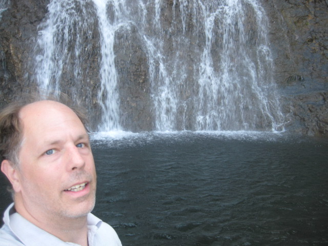
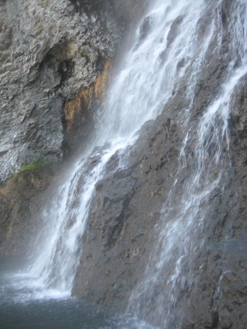
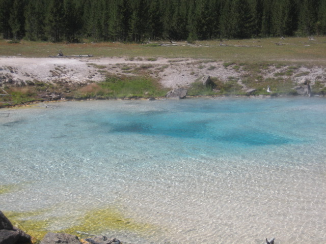
I need to digress here to mention that my hiking book, in which the author rates all the back country campsites in Yellowstone on a star system, awards five stars to site OD2 (the one that I’d just passed) and only four stars to OD3. I had nevertheless chosen OD3, based on the descriptions given of each; OD2 was said to feature “a spectacular view of the Little Firehole Meadows,” whereas OD3 supposedly provided a view that was “good but not quite as good,” yet was also described as being “next to a small waterfall.” In my head, I couldn’t imagine what could possibly be “spectacular” enough about meadows to top a waterfall, so I had ignored the author’s clear preference for OD2. Well, now that I was there, I found that I had absolutely made the right decision! In the first place, I didn’t see anything that looked like “meadows” anywhere within sight of either campsite (!?), so I have no idea what the author was on about. Secondly, I stand by my general view that meadows would be hard-pressed to compete with a waterfall under just about any circumstances. And third…well, I’ll let a picture make point #3 for me.

So, order of business #1 (after unburdening myself of the 20-ton backpack, that is) was filling up my water bottle and quenching my thirst. After that, having found that I could barely walk because my balance was off from having had that weight on my back all day and now suddenly being free of it…on top of overall total exhaustion and both feet really hurting…I laid myself out on a large fallen tree at the edge of the campsite and just zoned out for about fifteen minutes. Once I had recovered enough to think about next moves, I got in touch with the ravenous hunger that I had barely even noticed until that moment, and knew that I was going to need to see to dinner before too much longer. But any reader of this tale who hasn’t guessed that going for a swim in the spot pictured above was an even higher priority is probably a reader who doesn’t know me very well! I had swimming trunks with me, but I couldn’t immediately find them, and I was also too tired to really try very hard. I was 100% alone in the middle of nowhere! Underwear would do. 🙂 I stripped down, made my way to the edge of the stream, waded in, and crossed the shallow, rocky section by the shore to a little island not visible in the picture above (you’d see it if you could pan around to the left). From there, a smooth, gravely bottom sloped gently down into the pool that the falls have carved out. I waded in until the water came halfway up my thighs, and then dove. The water was exactly what I needed: just cold enough to be intensely invigorating, and no colder. In an instant, it washed away the entire ordeal of the latter part of the day’s hike, and I was seized with an overwhelming surge of adrenaline and ecstasy! Again, those who know me will be aware that I don’t tend to be an especially excitable person. Regrettably, I often feel that I can be reserved and low-key to a fault. But after diving into the bracing waters of my private little swimming hole at the base of this beautiful little waterfall, miles from pretty much anything, at the end of a long, hard day of hiking…there was no holding back several involuntary whoops of pure joy and exhilaration! The exclamation “This is the best thing I’ve ever done!” may, just possibly, have escaped my lips as well. (Although afterwards, I did amend that to: “Well, the best thing I’ve ever done alone.”)
I lingered in the river for a while. I tried swimming toward the base of the waterfall, but the current was too strong; I maybe could have managed it if I had been at full strength, but in my present tired state, it was beyond my ability. So, I just enjoyed myself where I was…even if not for as long as I really would have liked. My swim wasn’t going to wash away my hunger, after all. Besides, I sensed that it was right at that point in the early evening when it was going to start to cool off soon, so before long I probably would get cold in the water. I felt 300% better after my swim than before it, but I still found that once I was out of the water, I barely had the energy to stand upright. So I took it slow, going about the business of boiling some water using my borrowed miniature propane burner and using it to hydrate the freeze-dried chicken & dumplings backpacking meal that I had brought with me.


After I ate, still moving slowly, I started working on organizing my stuff, getting my tent set up, and generally securing the campsite for the night. I had stuffed a few mint oreos in with my food for the trip, but I found that my stomach wasn’t interested in a bunch of sugar, so I skipped dessert. Instead, I just crawled into the tent and collapsed. It wasn’t even dark yet—there were still a good couple of hours, at least, of slowly fading daylight—but I lacked the energy even to try to read. Paradoxically, I also found it hard to actually sleep for some while. (I would try to blame the relative discomfort of the tiny sleeping pad that I was lying on, but then, I had all but fallen asleep lying on a downed tree earlier, so I don’t know about that.) But of course, eventually I did sleep.
The next morning was somewhat of a repeat of the previous one, with me feeling the need to lounge around and continue to rest for several hours before tackling the rest of the hike. I suppose that, in effect, all I was really doing on these two days was reversing my otherwise-normal pattern of being active in the morning and afternoon, and then relaxing at my campsite in the evening…although, today, I would end up with evening relaxation time as well. In any event, I had another lazy morning. At some point I boiled some more water and made the second of the two freeze-dried meals that I had brought (this one was a breakfasty eggs/onions/peppers/sausages type concoction). I did some reading, and of course (once it had warmed up a bit from the morning chill, and once I had regained enough energy) I splashed around in the river a bit more (although no full-on swimming this early in the day). Then, eventually, I decamped, packed up, and hit the trail again…maybe around noon? I don’t recall for sure.
Today’s hiking didn’t involve any murderous uphill slogs, and the total distance was shorter than yesterday’s. And it was a good thing, because even after resting all morning, I still didn’t have much stamina left—at least, not with the heavy pack on my back. Plus, of course, my various foot issues made walking at all (or even just wearing shoes) painful. Still, I was in reasonably good spirits. Despite everything, yesterday’s trek, I felt, had been totally worth it…and also, I just felt a sense of accomplishment. True, I had not yet completed my adventure, but I had done the overnight-in-the-back-country part! And, physically tired though I was, I felt fully confident in my ability to hike the rest of the hike. In the event, it went by pretty quickly, even. I can’t quantify how long anything took, per se, but I was pleasantly surprised by how soon I found myself at the fork in the trail that meant that I was joining the loop route via which Mystic Falls can be reached from the Biscuit Basin trailhead (see map). As I paused to consult both the sign and my book (to make sure I knew which way to go), two women (a mother and (adult) daughter, as it turned out) approached my location, coming from the left. Inevitably, they asked me how far it was to the falls (assuming that I was simply hiking the loop from Biscuit Basin in the opposite direction from them, and would thus have already passed Mystic Falls). So I explained that actually, I had come from the other path, and had spent the night out there, and that they were in fact the first other people I’d seen since the previous afternoon. They were duly impressed, and had all kinds of questions about my experience, so we chatted a bit as we proceeded along the path.
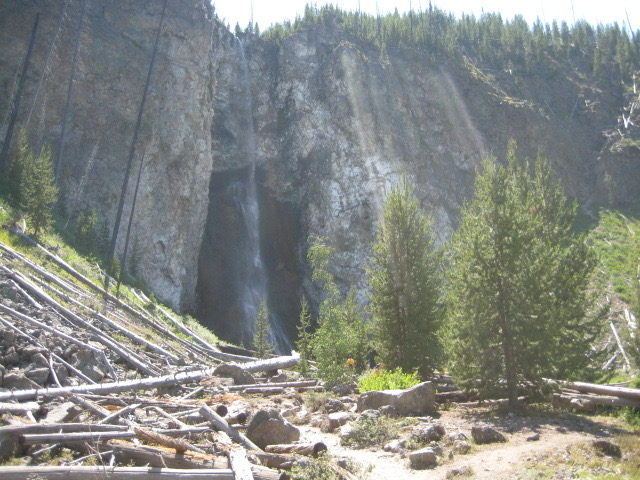
Before long, Mystic Falls started coming into view.


Just like at Fairy Falls on the previous day, there were quite a few people who had hiked out from Biscuit Basin and were enjoying Mystic Falls today. Here, though, a lot of them were adventuring around on the rocks, kind of between “stages” of the falls.

Personally, I set down my pack, changed into water shoes, fished out my still-uneaten peanut butter sandwich, and descended to a spot at the edge of the river a bit downstream from the folks in the picture above, where I sat myself down with my feet in the water to rest and munch and enjoy the view. (I had to be really careful making my way down the bank; it was moderately treacherous to begin with, and I was also still having that weird experience of being off-balance whenever I took my backpack off.)


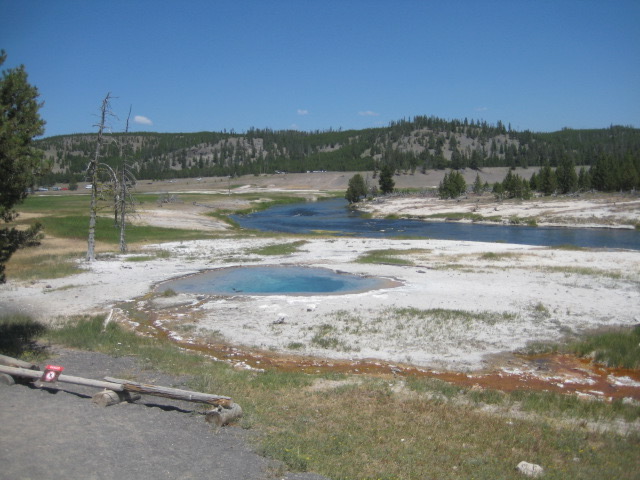
After this pleasant pause, it was just a mile or so (slightly more, probably) of easy going to reach the Biscuit Basin trailhead. Biscuit Basin is a sort of extension of the Upper Geyser Basin (aka the Old Faithful area), located on the other side of the loop road from the Old Faithful area proper but connected to it via trails that cross the road. As with all the road-adjacent, “main attraction” thermal feature areas in Yellowstone, it has a boardwalk that loops around past various geysers and hot springs and whatnot, with informational signs and stuff. Jen and I hiked the loop from Biscuit Basin to Mystic Falls and back way back in 2009, but although I vaguely recalled the falls (aided by pictures that we took at the time, of course), I didn’t really recall Biscuit Basin, and would have probably said that I didn’t think I’d ever walked this particular boardwalk before now, but for the evidence to the contrary. In any case, by the time I got here today, I was so tired and footsore and eager to press on and get done with my hike (recall, I still had 2.3 miles of walking along the side of the road ahead of me, to get back to my starting trailhead, where my car was parked) that I said to myself that any geyser-gazing and etc. that I might want to do here could wait for tomorrow (planned as my main thermal feature sightseeing day for this trip). Of course, just a few minutes after telling myself “no pictures, just keep moving,” my path took me past a beautiful blue hot spring that I couldn’t resist pausing to snap a picture of.

There was a park ranger hanging around on the boardwalk not far from Sapphire Pool, answering people’s questions and regaling them with facts about the thermal features. As I passed her, she caught sight of my gear-laden pack, and asked me if I had been backpacking overnight in the back country. When I responded in the affirmative, she of course wanted to know what route I had hiked, where I had stayed, and how it had gone, so I took a moment to chat with her. She was full of praise and approval, which felt nicely validating. Then it was onward, across the bridge over the Firehole River, past the Biscuit Basin parking area, and onto the gravel alongside the road, for the final (and least interesting) leg of my journey. It was about 3:00 in the afternoon when I started walking up the side of the road, and about 3:45 when, at last, I reached the unpaved overflow parking area just to the south of Grand Prismatic Spring, where my car was waiting for me. It had been almost exactly 26 hours since I had locked it up and left it behind me the previous day. Delighted to be able to doff my near-infinitely heavy pack for good, I collapsed, with a now vastly reinforced feeling of accomplishment, into the driver’s seat, immediately starting the engine so as to blast the a/c. I had done it!
I won’t dwell at length on the remainder of this day. I drove back to Grant Village, treated myself to a root beer float from the ice cream place inside the general store, took care of some other needs, and headed to my campsite, where—similarly to when I had first arrived at the back country site the previous evening—I collapsed on my reclining patio chair and zoned out for a while. Later, not feeling up to the effort of building a fire and cooking dinner, I decided to allow myself a visit to the restaurant at Grant. They were doing take-out only (or you could sit at one of like three available outdoor tables), so I brought my bison burger and onion rings back to my campsite and ate at my picnic table, still enjoying the relative luxury of these accommodations in comparison to site OD3. I wasn’t completely zonked, like I had been the previous night, so I was able to read and futz around on my laptop as the evening wore on, before eventually hitting the sack at a normal (for camping) hour.