Here’s part two, which recounts our first two days actually in the park:
Day Three (Monday, June 29th)
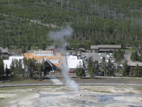
The first thing on our agenda for our first full day in the park was to head to the Old Faithful area and see that and the various other thermal features in that area (the Upper Geyser Basin). Due to the elevation, it gets cold at night in Yellowstone—down around 40 most nights while we were there—and although we kept pretty warm in our sleeping bags, it was necessary to put on jeans and sweatshirts when we got up in the morning. Thusly were we attired, therefore, when we arrived at the Old Faithful area parking lot (which, due to our early-morning rising, was still all but deserted when we got there). Old Faithful was scheduled to erupt within about 15 minutes, we found, so we grabbed seats on the observation benches and waited for it—but alas, due to the morning chill, all we could really see when it did go off was steam that condensed so thickly around the water spout that the water itself was mostly obscured. Deciding to try to catch it again later in the day, therefore, we set off along the boardwalk that winds all around the area past numerous other geysers, hot springs, and fumaroles (steam vents). There was also a trail leading off of the boardwalk and up a rise through the woods to a kind of scenic overlook point, and we decided to hike up it—but by now, it was suddenly getting much warmer, and although Jen had dressed in layers (with a t-shirt underneath her sweatshirt), I hadn’t. Also, we’d eaten nothing but a couple of breakfast bars since rising. So when we hit the steep terrain leading up to the overlook, I was sweating buckets, feeling weighted down by my clothing, and also suddenly very hungry. The fact of being unaccustomed to the elevation surely played a role, as well. In any event, even though the trail was really not very long at all, we decided to turn back and prepare more adequately for it before proceeding. I changed into shorts and a t-shirt that I had along in the car, and we had a quick (brunch?) of peanut-butter sandwiches while sitting on the trunk of our car.
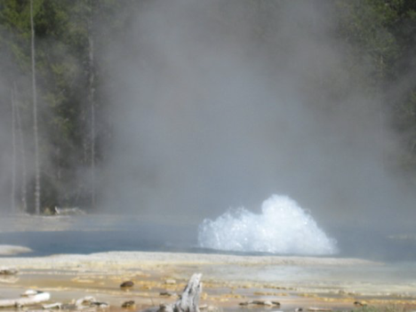
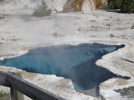
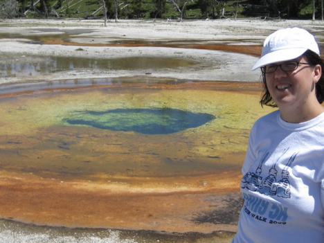
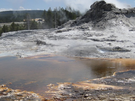
We then once again headed up to the scenic overlook, feeling much better (though the short hike was still exhausting, at least for me—a fact that I chalked up to the elevation). The trail also led to Solitary Geyser, which is up the hill and out in the woods away from all the other thermal features along the boardwalks down below. After hiking back down, we proceeded to walk the maze of boardwalks and see many of the numerous other thermal features. I theorized that the real explanation for the geysers and fumaroles (my new favorite word, by the way) was that there was a mysterious underground industrial civilization, like in The Time Machine, and these were their smokestacks and wastewater spouts and whatnot. However that may be, touring the boardwalks was fun, but also utterly exhausting (again, I think we were adjusting to the elevation)—and what with the cold morning, it had not occurred to either of us to put on sunscreen, either. I got a nice red stripe across the back of my neck, and another across the top half of my face (though I’ve certainly been sunburned much worse on other occasions; by the end of the week, it had already stopped hurting). One particular geyser that we saw was spurting spasmodically (though it wasn’t Spasmodic Geyser—that was a different one) and was quite near the boardwalk, so that its spray was landing on the boardwalk and getting it all wet. It sprayed us as we went past it, and was therefore my favorite (Sawmill Geyser was its name). Also notable was a feature that a map labeled as Tortoise Shell Pool. We wanted to take a picture of it (for Andante, you see), but it was hard to figure out exactly which feature Tortoise Shell Pool was. The map seemed to be indicating one of the bubbling pools right next to Castle Geyser, so I took some pictures of that, figuring one of them would probably include it.
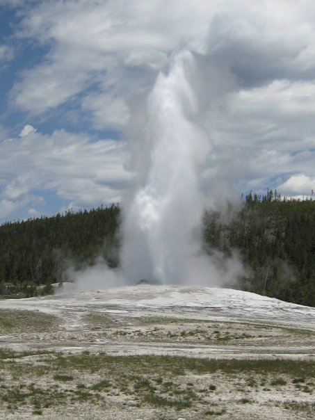
Finally, we made our way back to the immediate vicinity of Old Faithful, where there was now a huge crown gathered along the boardwalk and on the benches where we’d sat with just a handful of people to watch the earlier eruption. Deducing that it must be about to go off, we stopped to wait and watch (even though, speaking for myself at least, my feet were killing me by this point). A few minutes later, erupt it did, and I took pictures. This time it actually looked like a geyser erupting, and it was very impressive and satisfying.
We then moved with the enormous crowd away from the thermal features and toward the parking lot, store/gift shop, and whatnot. We headed into the store to pick up some ice for our cooler, and perused the souvenirs and such just briefly (it was too crowded, and we—or at least I—were/was too footsore, to spend much time). We did pick up a deck of Yellowstone National Park playing cards, though, with which we would pass the time at our campsite every evening until the end of the trip.
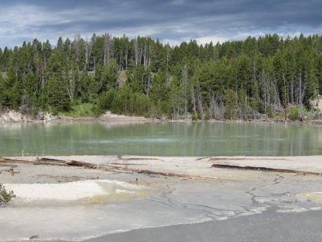
The plan for the day had been to investigate the swimming after seeing the geysers, so we next set off in our car up the road toward Firehole Lake Drive, which is a one-way scenic loop off of the main road. There was a picnic area—Whiskey Flats, it was called—just off the main road shortly before the start of the scenic loop, so we stopped there first and had a lunch of more sandwiches. After eating, we proceeded to Firehole Lake Drive—but although we saw the lake, and some more geysers and hot springs (Great Fountain Geyser even sprayed our car as we drove past it), we did not see any swimming areas, or even any areas where one could park and approach the lake without having to traverse areas marked with signs as being dangerous thermal areas that you weren’t supposed to walk on. My despair—and puzzlement—revived. The woman had said there was a swimming area here! Jen thought that maybe her quip about how this was where to go if I was “determined to get in the water” meant, basically, that there really was no swimming area, but that if I was crazy enough to want to swim in the too-cold waters of the park, this was the least crazy place to do it, or something. Still, we didn’t even really see a place where that was feasible along the drive—and what of my pre-trip internet info? It was puzzling and frustrating, but although I had a hard time letting go of it, for the moment I tried to just accept that there might not be any swimming to be had during our trip.
That, I believe, was it for the “out and about” portion of this first day in the park; after failing to find a swimming area, we headed back to our campsite, where we passed the time playing cards until we were ready for supper. When that time came, I discovered that we had “intelligently” left our corn-on-the-cob sitting on the back dashboard of the car instead of putting it in the cooler, and it had gone bad in the day’s sun. Still, we had another delicious meal of brats, albeit without the corn accompaniment that I’d planned. We had to eat said meal in the car, too, because it started raining just as we were getting ready to eat—but we didn’t mind too much, since the rain had at least been polite enough to wait until we were finished cooking over the fire. After supper, we retired to the tent (it still being inclined to rain intermittently), where we continued playing cards until we were ready for bed.
Day Four (Tuesday, June 30th)
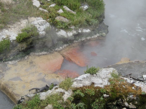
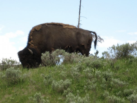
On our second full day in Yellowstone, we decided to look into the horseback riding that Jen had been so looking forward to, as well as to take in the Grand Canyon of the Yellowstone. Accordingly, we headed some ways up the road that we had driven down on Sunday to get to our campground, along the lake and then through the Hayden Valley (the latter being buffalo territory). Along the way, we decided to stop off at the Mud Volcano area and walk the quick boardwalk to see the weirdly bubbling mudpots and smell the unpleasant stench of sulfur (more signs of that subterranean industrial civilization, to be sure). A buffalo or two wandered serenely not far off, though not too close for comfort, either. It being, once again, early in the day, we were able to tour the mudpots without having to fight through crowds—which was nice.
Following this stop, we proceeded up toward Canyon Village and stopped at a horse-riding place a short ways before the village area. Unfortunately—and this next part is a tad bit embarrassing—a sign outside the building there mentioned that in order to sign up for a horseback ride, one had to weigh no more than (if I recall correctly) 250 pounds. Since I’m quite a bit heavier than that, we were dismayed, but we went inside and inquired anyway. Alas, though, there was no getting around the fact that I was too fat to go horseback riding. This rather put a damper on our plans—not to mention our spirits—and we returned to the car in a state of disappointment. Distracting us from this somewhat, a buffalo wandered up into our immediate vicinity while we were sitting in the car mulling over what to do next.
I felt really bad, especially since I knew how much Jen had been looking forward to horseback riding—but Jen seemed disposed to shrug it off and make the best of it, so I tried to do the same. As an aside, it’s worth noting that this experience prompted me to decide to get serious about dieting and exercising upon our return home after the trip.
Ultimately, we decided to proceed to Canyon Village and stop in at the visitor center there to find info about hiking in the canyon area. I think, though, that we were still feeling a little let down and at loose ends over the horseback riding thing, so we ended up dawdling in the visitor center a bit; we looked at some of the exhibits and stuff, and decided to sit in on a couple of little films in their theater that were about the park. These didn’t prove to be terribly informative (at least to those of us who had already read about the park and its features and whatnot from various pamphlets and signs), but by the time they were over, we were feeling ready to head out for some hiking. Armed with a trail map, we thus headed via car to the canyon’s North Rim Drive and parked in one of the parking areas from which trails are accessible. Mindful of the lessons of the previous day, we ate a quick couple of sandwiches atop the trunk of the car—and also put on sunscreen—before setting out. I was also properly attired in a t-shirt from the outset this time.
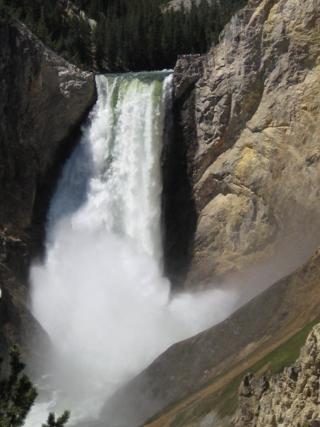
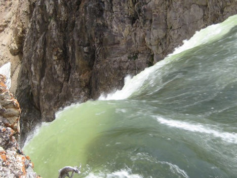
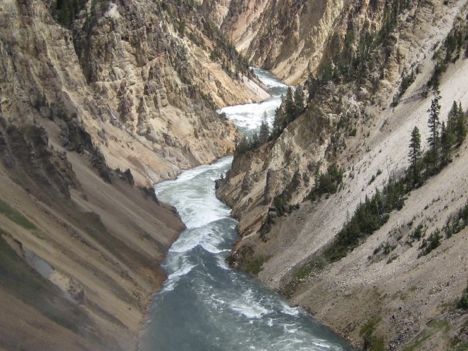
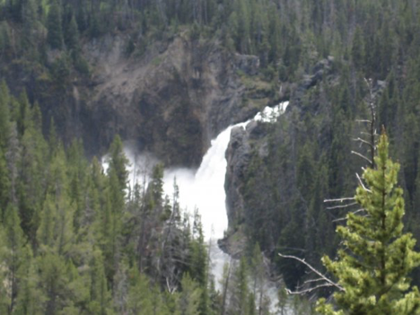
The parking area that we were at was a short ways downstream from the spectacular and famous Lower Falls. There was a very short walk to a Lookout Point, which we took first, and a steep, hairpin-turn-type descent to a better vantage point below the falls, which we did next. The scenery was gorgeous—the river and the canyon, of course, but also the little stream running down into the river that paralleled the trail. Of course, the return trip back up the steep trail was extremely strenuous—but we had brought bottles of water and breakfast bars along to sustain us, and even though the uphill hike was murder, I felt that I must already be acclimating somewhat to the elevation, because I managed it much better than it seemed like I would have the previous day. When we got to the top, we hiked along a level trail (thankfully) that essentially paralleled the road we’d driven in on, along the canyon’s rim and back to another parking area that we had not parked at because there had not been any spots available there. From there, there was another steep-descent-type-trail that went to the “brink” of the Lower Falls, where the view was the most spectacular yet. The water was vibrantly blue and green as it rushed over rocks on one side of the observation area, looking achingly refreshing; then, right in front of us, it plunged over some smooth, rounded rock, and plummeted straight down who-knows-how-far, where it exploded into mist and created a rainbow. I liked it a lot.
The trip back up the second steep trail was even harder than the first one had been (I think it was longer—plus, of course, I was already tireder…), but when we got back up to the top, we nevertheless continued farther upstream along the level trail, taking in views of the Upper Falls and various other scenery, before turning around and heading back to the parking lot where we had parked.
Since it was getting on in the afternoon, and I, anyway, was utterly exhausted from all the steep-terrain-hiking, we headed for “home” upon getting back to our car—though we did stop at a store somewhere first (in Canyon Village, I think) to pick up some hamburger patties for our supper, since the brats that we’d eaten over the last two days had been all the meat we’d brought along from home. I ground plenty of garlic pepper onto the burgers as I was grilling them, and Jen thought they were delicious—although since I seem to invariably undercook my burgers, and since I am far less tolerant of less-than-well-done burgers than Jen is, I didn’t enjoy them nearly as much as she did. Also, probably before supper, we decided to shell out the two bucks apiece for showers on this evening—in my case, my first shower since just before leaving home Saturday morning. After supper, it once again decided to rain, chasing us into the car again briefly.