I’ve spent at least some time checking out the various “main attraction” thermal areas on each of my trips to Yellowstone, but there are some that I’ve visited many times, others that I hadn’t really visited since my first (as an adult) trip out there way back in 2009, and even one or two that I had never gotten to. In the planning stages of this trip, I decided that I would take one day to (re-)visit as many as possible of the geyser basins located along the western side of the main (southern) loop road—but I would try to keep my time in the Upper Geyser Basin (Old Faithful area) reasonably brief and “targeted” on just the few things I most wanted to see there, since it’s huge and can eat up tons of time (and also since I’ve been through that area pretty thoroughly on multiple previous trips). I probably wouldn’t even take the time to watch Old Faithful itself this year, I figured. I also knew that, in contrast to my plans for hikes ranging in length from 10 to 17 miles on other days, a geyser-gazing day would provide a (relatively) undemanding break. Finally, being me, I also figured that it would allow for an afternoon stop at the Firehole Canyon Drive swimming area, which anyone who happens to have read my accounts of previous trips knows is an awesome spot but one that eluded my attempts to have fun at it until 2018.
Well, geyser basin day was well-scheduled on this day after my two-day backpacking adventure. On one hand, I had managed to rest up enough that I did get going bright and early today, in contrast to the past two days; on the other hand, both my feet (but especially the one achilles tendon) hurt so bad that I felt like I could barely walk (even just wearing shoes hurt). So, it was definitely a day for taking things a bit easier (even if, in the end, I didn’t go quite as easy on the feet as I perhaps should have)!
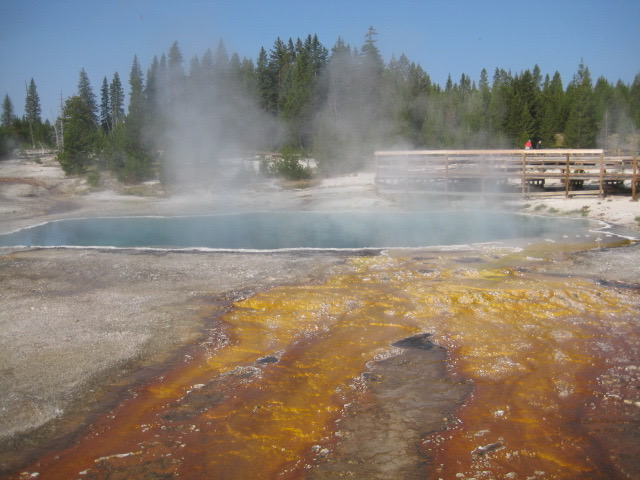
My first stop this morning was West Thumb Geyser Basin, which is right by Grant Village (where I was camping). I had driven past this spot many times on past trips, but never actually stopped to check it out before. It’s located on the West Thumb of Yellowstone Lake, which is a “caldera within a caldera,” formed from an eruption of some kind of sub-portion of the Yellowstone mega-volcano about 174,000 years ago (i.e., about 500,000 years more recently than the last mega-eruption, which formed the caldera that encompasses a vast portion of the whole park). There are still active hot springs and geysers on the lake bottom, and in some places along the shore, of the West Thumb…and those were was what I was there to see!


Besides hitting as many of the geyser basins as I could, I was also determined to stop at as many of the little roadside turnouts along the way as I felt like, to see whatever cool scenic views could be seen from them. There are tons of these all over the park, but too often I just drive past them on my way to whatever destination I am trying to get to.


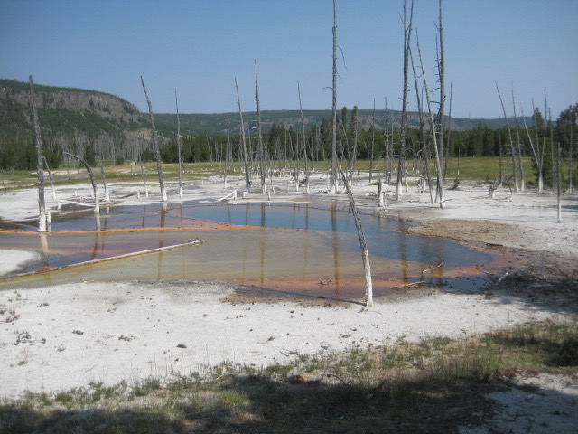
Across the main road from the Old Faithful area “proper” is Black Sand Basin, another spot that I’m not sure I had ever actually made it to before.


Next, I got to my “targeted” exploration of the Upper Geyser Basin / Old Faithful area…and inevitably, kind of strayed a bit from my goal of taking it easy on the walking today, too (although I could have done much worse). Instead of doing the usual thing and navigating the crazy traffic to park in the vast Old Faithful parking area, then passing through the visitor center (fighting crowds), circumnavigating Old Faithful itself, and venturing off among the labyrinthine boardwalks and (mostly) paved trails from there, I parked in a turn-out area alongside the road just south of Biscuit Basin, where a trail that leads between Biscuit Basin and the Old Faithful area crosses the road (it’s the trail that’s marked with a bicycle on the map below).
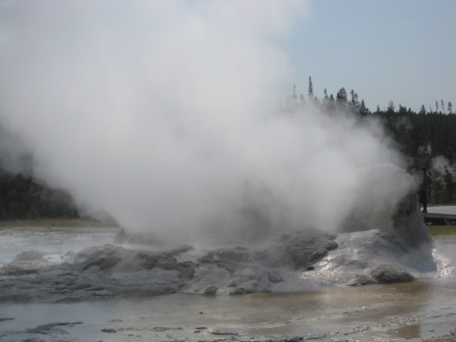
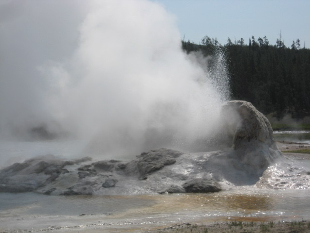
From there, water bottle on lanyard once again, I walked the path, paralleling the Firehole River, down to what I normally think of as sort of the “far end” of the Old Faithful area. I walked clockwise around the small loop circling Comet, Splendid, and Daisy Geysers, and then proceeded north along the main route, which immediately brought me to the vicinity of Grotto Geyser—long one of my favorite features in this area. Before I was even able to fully take in Grotto, though, my attention was grabbed by the fact that like two or three different geysers in its immediate vicinity were actively erupting as I approached!


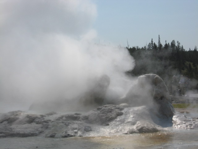

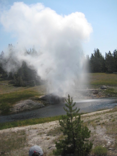
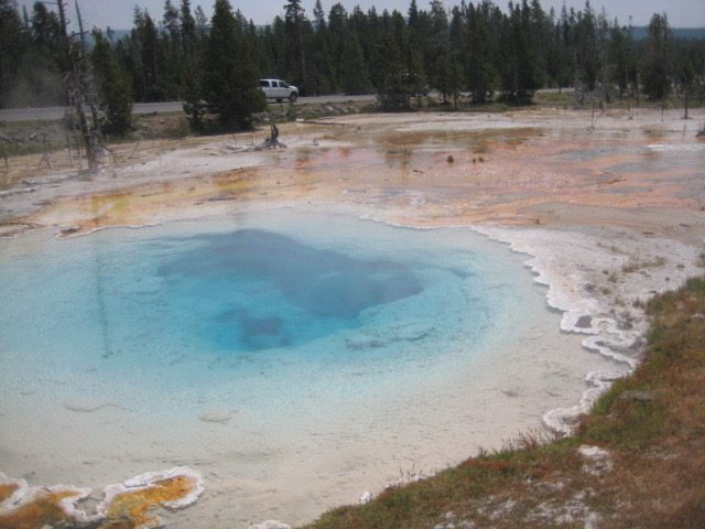
Just up the path from there, there’s a small loop off the main path that is designed to provide a view of Riverside Geyser (just across the Firehole from the path). I have wanted, for a long time, to someday get to see an eruption of Riverside Geyser. Described in the trail guide pamphlet as “one of the most picturesque and predictable geysers in the park,” it’s also one of a handful for which predicted eruption times are posted by the park service. Once every six hours or so, “a 75-foot column of water arches gracefully over the river” for about 20 minutes, often producing “rainbows in its spray.” It had been part of my plan, since well before I even left home on this year’s trip, that I would endeavor to find out Riverside’s eruption schedule before visiting this area, so that I could time my excursion here in order to catch it erupting. This, however, is tricky to do. There’s a Yellowstone app where the predictions are posted, but as noted previously, getting a cell signal just about anywhere in the park is hopeless, at least for me…and getting to the Old Faithful visitor center to check the posted times there requires dealing with traffic and crowds, and eats up time. So, in short, I had dropped the ball on this plan of mine. But it didn’t matter, because when I arrived at the spot for viewing Riverside Geyser, I found a sizable crowd gathered there. Did this mean what I assumed it probably meant? Yes! A signboard informed me that Riverside was predicted to erupt sometime within a roughly one-hour window that, upon my arrival, was already half over. All I had to do was wait 30 minutes or less, and I would get to see this thing that I had long wanted to see, and specifically intended to be sure that I would get to see on this trip, but in the end had failed to actually plan for!
Remember when I said in an earlier entry that everything about this trip seemed like it was either charmed or cursed? I was really on a roll today! However…and I don’t know how this happened…the video that I took of the eruption seems to not exist. That is, I remember taking a video of it, but now I don’t seem to have one. Did I flub with the camera and somehow not even notice? Apparently, the answer is yes. So weird, and a bit disappointing. But at least I have some still photos:


After all of that excitement, I moved on to Morning Glory Pool, at the farthest extreme of the boardwalk. I don’t want to repeat myself too much here from my accounts of past trips, but Morning Glory is spectacular and rightly famous…and then, a short ways up the much, much less traveled, unpaved trail heading off from here toward the road and Biscuit Basin, there’s a hot spring that I find even more amazing (and that may look more like what Morning Glory once looked like, before vandalism altered its color profile). I used to think it was called Artemisia, but in 2018, some family members and I chanced to discover that “Artemisia” is actually a small geyser lurking behind the vivid blue pool that so captivates me.


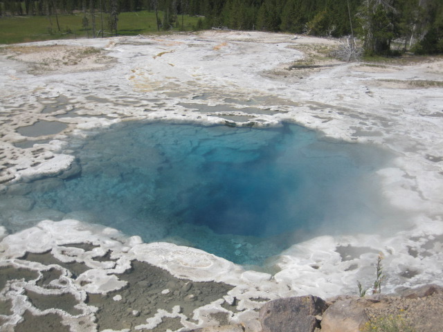
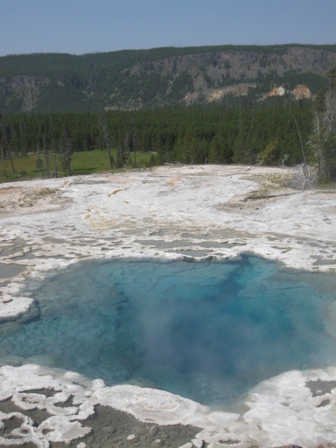

In past years, part of the thrill of this spectacularly blue spring for me lay in the fact that even though it’s just a few minutes’ walk from one of the most famous features in the park, I would always leave the crowds behind upon stepping off the boardwalk, and have this one entirely to myself. This year, alas, it was not so; a surprising number of other people were venturing along this semi-genuine hiking trail through the woods, rather than sticking to the boardwalks and paved paths. Maybe it was the time of year; in 2016 I was here in later July, and in 2018 I was here in August. Anyway, it was mildly disappointing…but not enough so to prevent the spot from still giving me a thrill. It retains its place on my short list of favorite spots in the park! (And Mom, if you’re reading this…you’ll be happy to know that the “stream” that you “forded” on the trail leading to the said spot was still there!)
Continuing along the trail, it soon took me back to the main road, which it crosses before heading into the Biscuit Basin area (i.e., the end point—but for walking up the road a couple miles—of my big hike of the previous two days). Having seen Biscuit Basin (however briefly) yesterday, and anyway really needing to give my poor feet a break, I did not cross to the other side of the road, but instead walked the short distance back along the road (and across the bridge over the Firehole River) to where I had parked my car.
It was also lunchtime, so I drove the short distance up the road to the Whiskey Flats picnic area—a spot where I’ve lunched so many times, on so many different trips to Yellowstone, that it would hardly even count as a trip to Yellowstone if I didn’t eat at least one lunch there. (There’s nothing all that special about it, really; it’s just very conveniently located!) Then I drove the short one-way side road off of the main road called Firehole Lake Drive, which I believe I had not done since 2009, and which looked nothing like what I remembered from that time. Admittedly, my focus was very different this time. Then, I’d either been misinformed or gotten it confused with Firehole Canyon Drive, and was mostly focused on looking for the alleged swimming spot. I do, though, remember spray from a geyser hitting the windshield of the car on that 12-years-ago drive along this road. No such excitement this time, alas.

Next up was the Lower Geyser Basin, aka the Fountain Paint Pot boardwalk. (I had bypassed the Midway Geyser Basin for reasons including the ridiculous traffic/parking situation that I saw there, the fact that I’d gotten a bit of a glimpse of it at the start of my big hike two days ago, and feeling pressed for time.) Fountain Paint Pot includes mudpots in addition to the standard geysers and hot springs (and fumaroles). As I’ve commented before, mudpots are weirdly compelling to see in person but really don’t tend to photograph well (though as usual, I still tried).


After this stop, I considered my options for the rest of the day. It was mid-afternoon at this point, and of course I still wanted to go for a swim. I had initially imagined getting up to Monument Geyser Basin, Artist Paintpots, and Norris Geyser Basin, all of which are further up the road, between Madison and Norris. (I’m pretty sure I saw Artist Paintpots in 2009, but I’ve probably never stopped at the others of these spots, despite driving by them and admiring them from the road (insofar as is possible) numerous times.) But I was sort of at the point where that sounded like an annoying amount of additional driving just to see more of the same sorts of (admittedly very cool) things that I’d been seeing all day, as well as feeling like my feet would really appreciate me not making them do much more walking today. So, I decided to head for Firehole Canyon Drive, in the hope that the swimming spot would be open. If it wasn’t, I figured I would just find somewhere else to jump in the Firehole River; people were swimming in all kinds of not-official-swimming-spots along the road, and I didn’t see why I shouldn’t do the same, if necessary. (It was kind of strange, though; I don’t recall seeing people doing this on any of my previous trips.) Anyway, I headed up the road to the turnoff for Firehole Canyon Drive and enjoyed the fantastic scenery visible from the said drive…but, predictably, the awesome swimming spot proved to be closed. (I guess mid-July is still too early in the season.)

I wasn’t too disappointed, though, since I had half-expected this outcome and (even more importantly) since I had a backup plan. There was one spot just down the main road (or upriver) of the end point of Firehole Canyon Drive where some other people were swimming, and another spot a bit further south, by a picnic area, as well. I stopped at the first of these. I’d been wearing my swimming trunks all day, in anticipation of an eventual swim, so that I wouldn’t have to bother with finding a place to change. The water was delightful and the current was really strong, so I had fun repeatedly struggling upriver a short distance and letting myself float back downriver. (I was by no means the only person doing this.) It was both enjoyable and relaxing; being in the water soothed my aching achilles tendon, and “walking” against the current didn’t put strain on it like walking on land did.
After my swim, I decided (with only mild misgivings) to pretty much call it a day. The misgivings mainly had to do with the fact that, in a way, this also meant that I had now basically done everything that I was going to do for this trip. I still had one more full day in Yellowstone ahead of me, but I had no activities planned for that final day. I knew that my one foot was in no shape for any hiking, so even a much-reduced version of my original idea about a day hike to the Shoshone Geyser Basis was off the table. (There’s no way to get to the Shoshone Geyser Basin via anything but a lengthy hike or a boat trip—that was part of the appeal!—but I had been thinking earlier that I might at least hike the 5.4-mile round trip paved path to Lone Star Geyser, whose 2.7 miles (one-way) made up the first leg of the hike I had wanted to do.) Instead, I was probably going to spend tomorrow just relaxing at the campground…something that I ordinarily would not do at a destination like Yellowstone, but that seemed called for in light of my injury. Besides, I had done a pretty big and impressive thing with my two-day hike! So, I told myself that it was okay to take a relaxation day.
On my way back to Grant, though, I stopped at a roadside turn-out area where a sign implied that one could catch a glimpse of Shoshone Lake (the geyser basin that I’d wanted to hike to is located by the lake’s western shore), and took a couple of pictures. Alas, this was as close as I was gonna get. 🙁


I had a particularly pleasant evening back at my campsite, including the most satisfying campfire of the whole trip (although the next night’s would be almost as good). I was even inspired to take a couple pictures—one of the actual fire ring area, and one of the sky off to my left while sitting in my chair by the fire.


The next day, as I discussed above, I just hung out at my campsite, recuperating a bit physically from the beating that my feet had taken over the past three days and just enjoying the simple pleasures of camping (plus, I admit, some futzing on my laptop). I didn’t take any pictures on this day. But I did bestir myself from my campsite repose long enough to do a bit of souvenir shopping at the Grant Village store, so I will end this post with some pictures that I took just now, almost three weeks later, of the two nifty items that I picked up while shopping. They’re souvenirs, but they’re also actual useful items—things that I would have sooner or later gotten around to buying (cheaper and less cool versions of) anyway. Being (again) me, my choices both ended up being more or less kitchen-related, too.


Hahaha! My first thought as I began to read your account of venturing off past Morning Glory was of “fording that stream”. It’s surely my dauntlessness that has inspired you in your hiking and backpacking adventures. 😉
Undoubtedly!